Venice – Donna Clifford

Ciao e benvenuto a Venezia !


Hi there! They say all good things must come to an end and unfortunately this is the case, as this is our final blog.  For my final Blog I shall be going back to Italy. I just love Italy (must be some connection I have with the place maybe it is because my name is Italian!) It is off to Venice this time. I had the pleasure of visiting this beautiful, romantic and historical city at the end of February 2010. It was during the Venetian carnival,  which happens annually two weeks before the Christian denominations of lent begin on Ash Wednesday.

Donna |112755861

person dressed and posing with Gondola in the background

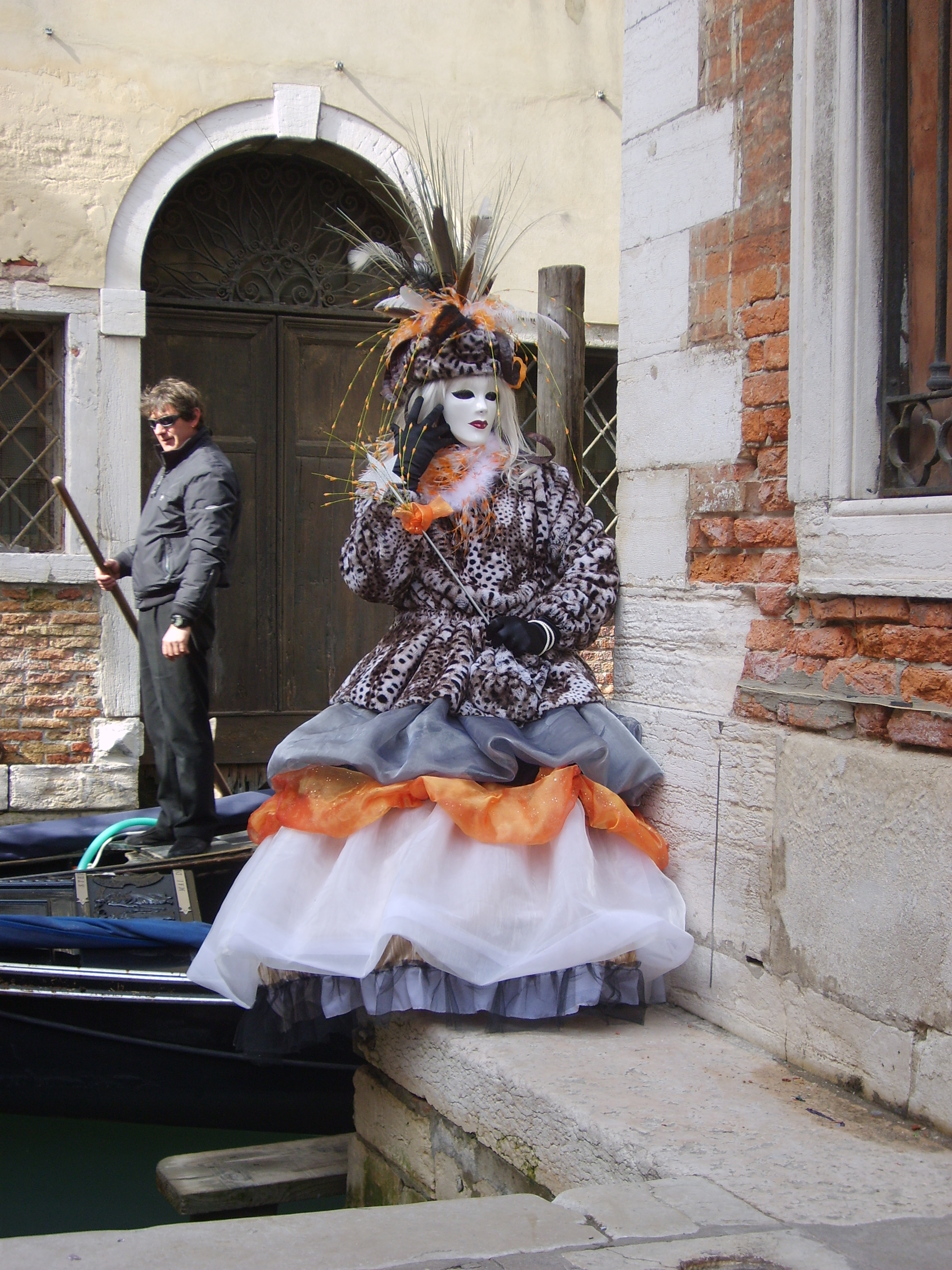
  person dressed  and posing for Carnival with Gondola in the background

The grand Canal


Venice is like stepping back in time and as it is a pedestrianised city you can just loose yourself in the city while walking around the narrow winding streets, over the small bridges that bring you across the lagoon. The Venetian gothic architecture of the buildings are just breath taking. During the late 17th/ early 18th Century an inspriing Architect by the name of Andrea Palladio his architectural designs is based on symmetry and classical temple architecture of the Ancient Greek and Romans. His building designs are still a major feature in Venice.


183649_204024419610478_1025653_n

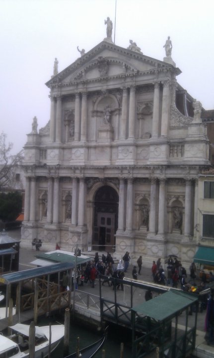
San Sate Church with its ‘Palladian’ Architecture


Another beautiful piece of architecture in Venice is the Rialto Bridge is one of the four bridges that stretches over the Grand Canal in Venice. The Rialto bridge is the oldest bridge that crosses over the canal connecting the districts of San Marco and San Polo.


'Rialto Bridge' The Arch the bridge's arch is higher than many bridges reaching about 7.5 meters this was to accommodate large galley ships passing through

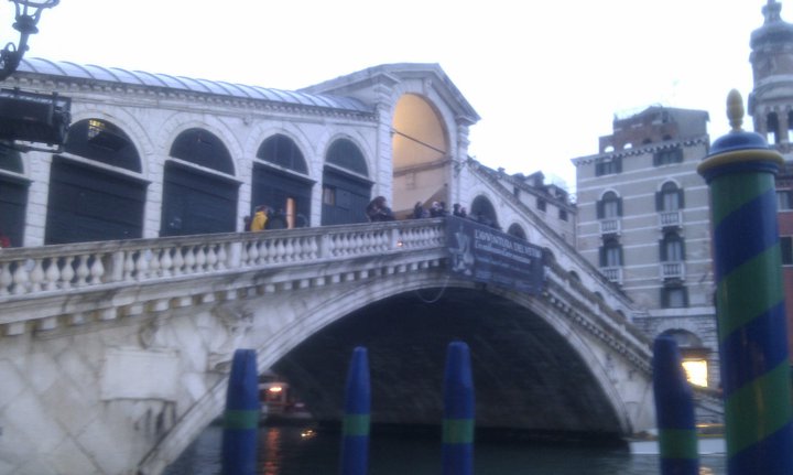
‘Rialto Bridge’ The Arch the bridge’s arch is higher than many bridges reaching about 7.5 meters this was to accommodate large galley ships passing through


Just over the Rialto bridge on the Eastern side is the flea market for tourist momentos and souvenirs from here it leads into the food market where you can get reasonably priced fesh produce of  fruit, vegatables meat cheese and especially seafood.

Walking down to Rialto Market

Walking down to Rialto Market

Campanile di San Marco stands at 98.6 meters (324 feet) tall and is located near the front of the basilica. Most of the building is simply a plain bricked structure, topped by an arched belfry that houses five bells. While we were there a man was cascading down the tower onto Basilica di San Marco by a zip wire.

Man cascading on a zip wire

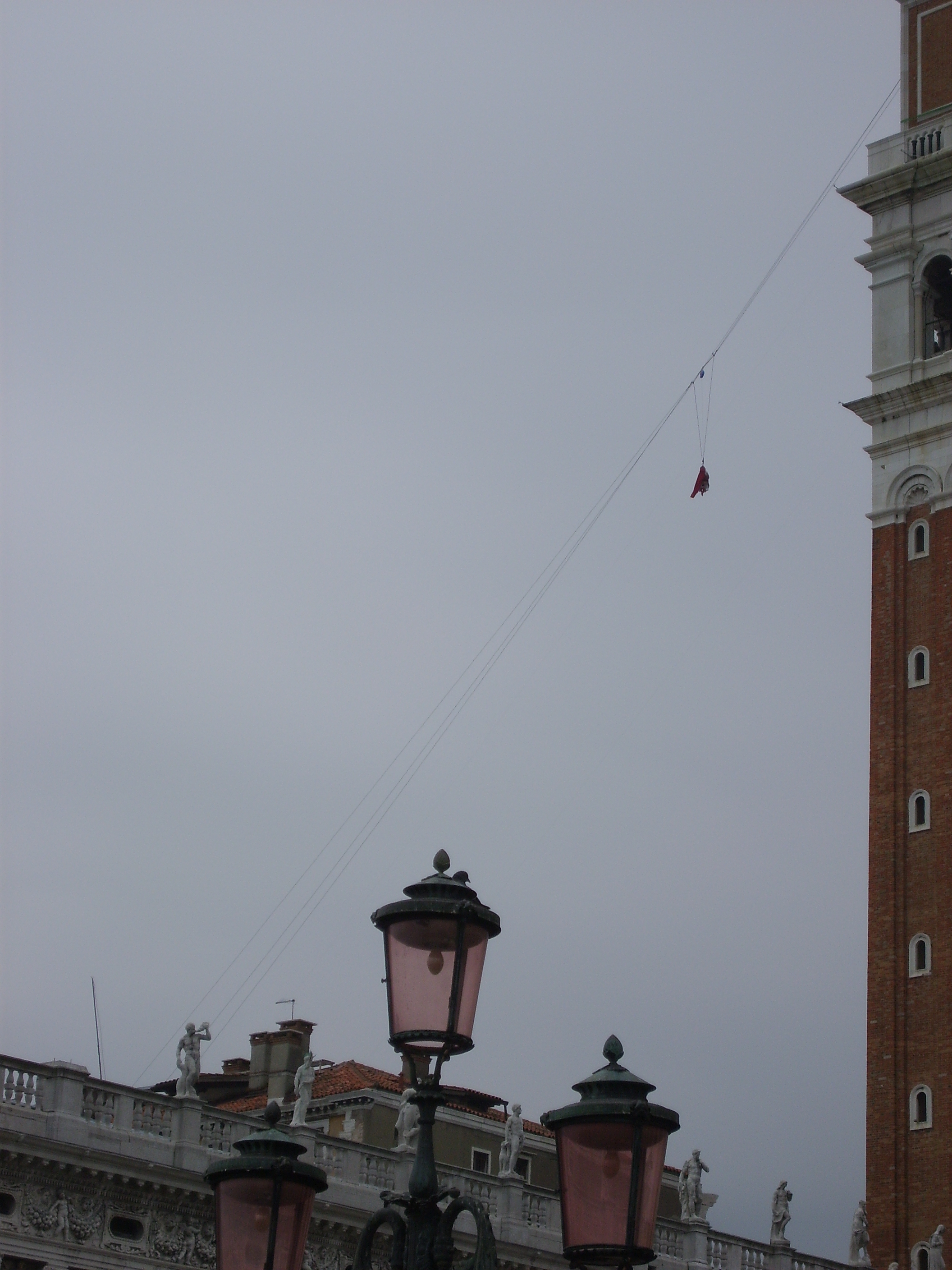
Man cascading down from the Campanile di San Marco on a zip wire

I will leave you all now with a few of my favourite photos from my time in Venice. Thank you for taking the time to read all of my blogs. Donna ARRIVEDERCI!


the Arsenal in Venice

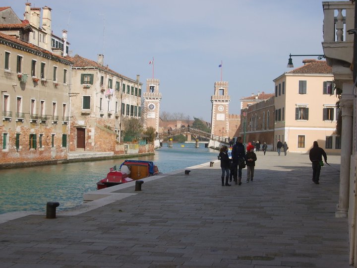
Te Arsenal in Venice


The Canal

The Canal

A parade walking though Piazza San Marco

A parade walking though Piazza San Marco

Just one of the many small bridges over the canal

Just one of the many small bridges over the canal

Marco Polo house

Marco Polo’s house

New York City – Donna Clifford


Welcome back!

We have been hoping that  you have been missing us but now we are back in style!

Last week, I explored the city of Rome in Italy with special regard to the use of squares and streets as prime social spaces within a city. This week, I have ventured to North America to the city of New York. In modern days, it is a metropolis of the modern world, a global hub of business. Interestingly, I have decided to step back in time and explore the city of New York in the 19th Century. The 19th century for  New York City provided numerous of changes. Major changes in urban infrastructure, transportation and technology revolutionised the city.

Donna|112755861


Image 1.1 – This image represents the 19th Century ‘New York’ City.

In 1833, the city established a Water Commission to plan a water supply system. Among the options for the water supply were the Bronx River, Morrisania Creek, Rye Pond and the Croton River. Major David B. Douglass, a hero from the War of 1812 and a West Point engineering professor, supported using the Croton River. Although this was the most expensive option, it could supply 40 million gallons of water a day to the city. The Croton Reservoir was also situated at a high level, so that it could supply the upper floors of city buildings.


Croton aqueduct

Image 1.2 – This bridge, which was completed in 1848, was the first to carry the Croton Aqueduct. It originally had a fifteen span stone arch bridge. This aqueduct brought badly needed fresh water to a growing city. In 1860, the bridge deck was increased in height to accommodate additional piping for more water. In 1872, the distinctive High Bridge Watchtower, which remains today, was constructed to control the water pressure.

By 1825 Gas illumination was widely available on the streets of New York and by the 1880’s had advanced to electric lighting.

broadway1880arclights

Image 1.3 – A change in urban infrastructure such as gas street lighting replaced oil lamps in the 1820s; starting at Broadway and Grand Street. In 1880, the first electric street lights arrived along Broadway between 14th and 26th Street.


By 1897 The Electric Vehicle Company begins producing Electrobat electric taxicabs in New York, the first commercially-produced electric vehicles


Electric Cars New York city

Image 1.4 – In 1891, William Morrison built the first electric automobile in the United States. This image effectively portrays the popularity of automobiles. Interestingly, you can also see how two modes of transport sharing the road system in inner city New York, the  horse and cart and the  automobile.


Interestingly, these new forms of transportation effectively “stretched” the cities out. First, trolleys veered over bumpy rails, and steam-powered cable cars lugged passengers around. Then with the addition of electric streetcars in cities; which was powered by overhead wires. Electric streetcars and elevated railroads enabled cities to expand, linking central cities to the once-distant suburbs.

New york railway

Image 1.5 – For my final image, I decided to explore the topic of the first elevated railway which successfully linked the ‘suburbs’ to New York City itself. These modes of transportation acted as a social force in rejoining the cities to their surrounding areas.

I hope you have enjoyed exploring these significant changes and the role they played in New York City in the 19th century.


Thanks for tuning in again this week,

I hope you enjoy reading this week’s blog posts!

Donna 


Biblography:


http://americanhistory.si.edu/lighting/19thcent/promo19.htm


http://www.musicals101.com/bwaythenow.htm


https://archive.org/details/gasilluminationi00bade


http://www.historicbridges.org/bridges/browser/?bridgebrowser=newyork/highbridge/


http://www.lib.uchicago.edu/e/collections/maps/transit/


http://www.nycroads.com/crossings/high/


http://www.searchanddiscovery.com/documents/2014/70168lash/ndx_lash.pdf


http://www.teachushistory.org/detocqueville-visit-united-states/articles/historical-background-traveling-early-19th-century