New York City – Donna Clifford


Welcome back!

We have been hoping that  you have been missing us but now we are back in style!

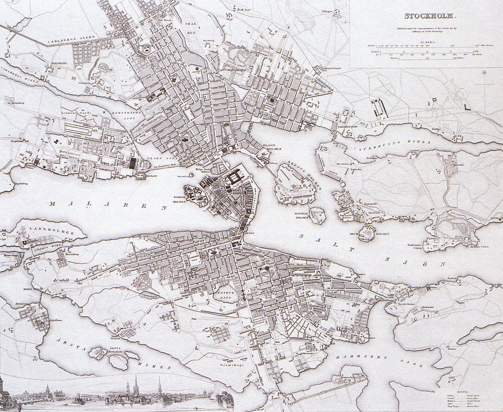
Last week, I explored the city of Rome in Italy with special regard to the use of squares and streets as prime social spaces within a city. This week, I have ventured to North America to the city of New York. In modern days, it is a metropolis of the modern world, a global hub of business. Interestingly, I have decided to step back in time and explore the city of New York in the 19th Century. The 19th century for  New York City provided numerous of changes. Major changes in urban infrastructure, transportation and technology revolutionised the city.

Donna|112755861


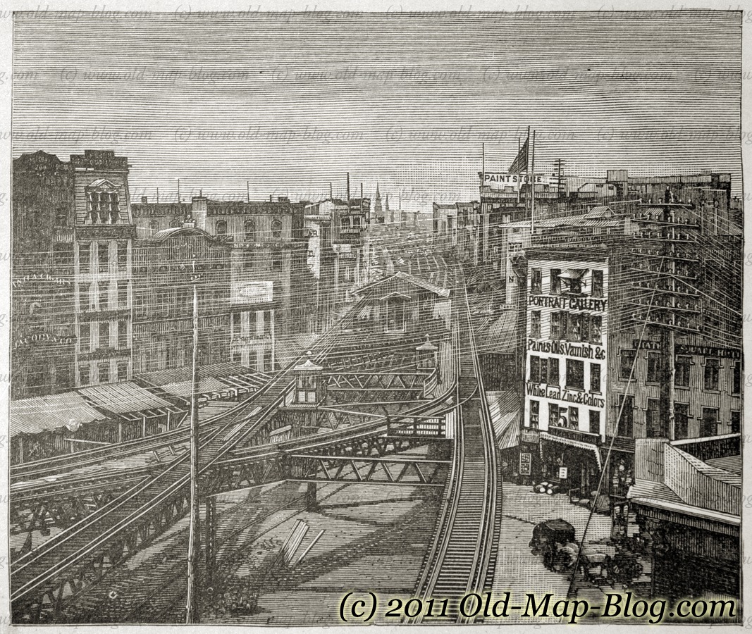
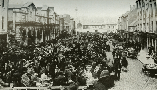
Image 1.1 – This image represents the 19th Century ‘New York’ City.

In 1833, the city established a Water Commission to plan a water supply system. Among the options for the water supply were the Bronx River, Morrisania Creek, Rye Pond and the Croton River. Major David B. Douglass, a hero from the War of 1812 and a West Point engineering professor, supported using the Croton River. Although this was the most expensive option, it could supply 40 million gallons of water a day to the city. The Croton Reservoir was also situated at a high level, so that it could supply the upper floors of city buildings.


Croton aqueduct

Image 1.2 – This bridge, which was completed in 1848, was the first to carry the Croton Aqueduct. It originally had a fifteen span stone arch bridge. This aqueduct brought badly needed fresh water to a growing city. In 1860, the bridge deck was increased in height to accommodate additional piping for more water. In 1872, the distinctive High Bridge Watchtower, which remains today, was constructed to control the water pressure.

By 1825 Gas illumination was widely available on the streets of New York and by the 1880’s had advanced to electric lighting.

broadway1880arclights

Image 1.3 – A change in urban infrastructure such as gas street lighting replaced oil lamps in the 1820s; starting at Broadway and Grand Street. In 1880, the first electric street lights arrived along Broadway between 14th and 26th Street.


By 1897 The Electric Vehicle Company begins producing Electrobat electric taxicabs in New York, the first commercially-produced electric vehicles


Electric Cars New York city

Image 1.4 – In 1891, William Morrison built the first electric automobile in the United States. This image effectively portrays the popularity of automobiles. Interestingly, you can also see how two modes of transport sharing the road system in inner city New York, the  horse and cart and the  automobile.


Interestingly, these new forms of transportation effectively “stretched” the cities out. First, trolleys veered over bumpy rails, and steam-powered cable cars lugged passengers around. Then with the addition of electric streetcars in cities; which was powered by overhead wires. Electric streetcars and elevated railroads enabled cities to expand, linking central cities to the once-distant suburbs.

New york railway

Image 1.5 – For my final image, I decided to explore the topic of the first elevated railway which successfully linked the ‘suburbs’ to New York City itself. These modes of transportation acted as a social force in rejoining the cities to their surrounding areas.

I hope you have enjoyed exploring these significant changes and the role they played in New York City in the 19th century.


Thanks for tuning in again this week,

I hope you enjoy reading this week’s blog posts!

Donna 


Biblography:


http://americanhistory.si.edu/lighting/19thcent/promo19.htm


http://www.musicals101.com/bwaythenow.htm


https://archive.org/details/gasilluminationi00bade


http://www.historicbridges.org/bridges/browser/?bridgebrowser=newyork/highbridge/


http://www.lib.uchicago.edu/e/collections/maps/transit/


http://www.nycroads.com/crossings/high/


http://www.searchanddiscovery.com/documents/2014/70168lash/ndx_lash.pdf


http://www.teachushistory.org/detocqueville-visit-united-states/articles/historical-background-traveling-early-19th-century

CORK AND ITS MARKETS – JENNIFER EGAN

Dowcha bai!

Excuse my (woeful) attempt at Corkonian, I’m afraid I’m not a native!

While I ventured abroad for my last blog post, I’ve decided to stay closer to home this week and delve into Cork’s past to explore it’s history of food retail and it’s markets, specifically during the 19th and early 20th centuries which for Cork, was an interesting period indeed. For the purpose of this blog, I’m going to hone in on The English Market, Cork Butter Market, St. Peter’s Market and street sellers down along the, as it’s colloquially known, Coal Quay. This week’s task requires us to create a story through digital photographs which surprisingly started out a little difficult with very few online archives storing many photographs of Cork’s markets.

“Still images can be moving and moving images can be still. Both meet within soundscapes.” ~ Chien-Chi Chang


The photograph of the Queen of England visiting The English Market took worldwide media by storm and became one of the most iconic photographs of the year. What was the reason for this? So what if Queen Lizzy visited the place I do some of my weekly shopping? This got me thinking of the importance of markets to Cork and it’s food-scene.

The economic prosperity of Cork grew in the 18th Century and was based primarily on the provisions trade; salted beef, pork, butter and the like were exported to the West Indies to provision the British navy. The unrivaled ability of Cork Harbour to shelter huge fleets was of course a major factor in the expansion of this type of trade. Cork Butter was internationally renowned and became the largest butter market in the world for its time because of this ability to export huge quantities of goods.

Image 1.1 Grand Parade entrance of The English Market with tramline passing outside.
Image 1.1 Grand Parade entrance of The English Market with tram-line passing outside. This perhaps provided transportation for those frequenting the market with their load of shopping. Sourced from Cork City and County Archives’ current exhibit named Cork:Merchant Heritage.

As well as being able to ship stuff out, huge cargo ships had easy access into Cork’s Harbour. It allowed exotic food stuffs such as spices from the East to be imported and sold to the people of Cork, or at least to the more affluent. With this, saw the opening of The English Market in 1788 as a flagship municipal market located at the heart of the new CBD (central business district for those less geographically inclined).

Image 1.1 This photo captures a moment on any given day in The English Market back in the 19th Century. Sourced from The English Market's archives.
Image 1.2 This photo captures a moment on any given day in The English Market back in the 19th Century. Photographer unknown. Sourced from The English Market’s archives.

This photo is very showing of the time as the majority of the people doing their shopping are in fact women and their children. Not only this, but they are very well dressed which perhaps is telling of their social class. Although the English Market was praised by many, it only served the prosperous. The less well off shopped in what was known as the Irish Market, St. Peter’s Market which had entrances on North Main Street and Cornmarket St. Food prices were more affordable here.

Image 1. St. Peter's Market Street Front. Sourced from Michael O'Leary Collection of Cork City Council Archives
Image 1.3 St. Peter’s Market Street Front c. 1900. Sourced from Michael O’Leary Collection of Cork City Council Archives.

Above is the shop front of St. Peter’s Market (where today lies the Bodega) which was completed in 1843. It was, in a way, the centerpiece of Cork’s market revolution. It was designed by the renowned architect Alexander Deane and modeled on St John’s Market in Liverpool, the largest in the U.K. Its hundreds of stalls sold meat fish and vegetables to the Cork working class. The quality of the food was below par with its grander counterpart, however the medieval town dwellers who enclosed their settlements with defensive walls greatly depended on the market for their supply of food and other necessities.

Image 1.4 Coal Quay, 1904. Sourced from The South...
Image 1.4 A bustling Coal Quay, 1904. See the difference of this bustling crowd compared to the desert St. Peter’s Market (no wonder it didn’t survive!) Sourced from The South of Ireland Illustrated with Descriptive Letterpress and Maps.
Image 1.  Roadside Butter Market Vendors, Cork. c. 1900
Image 1.5 Roadside Butter Market Vendors, Cork. c. 1900. Photographer unknown. Sourced from Cork City Libraries.

“The virtual porosity between the ‘covered street’ that was St Peter’s and the bustling real street outside down by Coal Quay (shown above) proved ultimately fatal to its prospects. It was never able to establish its own distinct, insulated identity as the English Market had done. While the latter continued to turn a healthy profit for the corporation, justifying continued expenditure on it and copperfastening its identity in the process, the Irish Market rapidly became a loss-maker. By early 1905  fifty-eight stalls in St Peter’s were vacant and its annual income of less than £500 was over £200 less than it had been the mid-1880s. Estimated expenditure on the market for 1906 was £600.” (http://www.englishmarket.ie, accessed on 01/11/2014)

In the mid 20th Century the remaining handful of stallholders in St Peter’s Market were given notice of eviction so to speak and were offered alternative pitches in The English Market. The Irish Market was no more. Present day Cork still enjoy weekly markets down by the Coal Quay and are invited to enjoy the creaminess of it’s once world famous butter at the Cork Butter Museum. The English Market is what cork is known for, it has been a symbol of the city since its opening welcoming both citizens and tourists alike to enjoy its very successful innovations and creations of artisan foods.


I guess that explains my question; I’m sorry I ever doubted the Queen’s decision to come visit!

Image 1.6 Queen with Pat
Image 1.6 Queen with Pat O’Connell of K O’Connell Fish. Sourced from The English Market’s archives.

I hope you’ve enjoyed your perusal of my blog installment this week, despite it not being as exotic as the others’! Keep your eyes peeled for next week when I get the opportunity to showcase some of my own photography skills.

Bye, bye, bye, bye, bye, bye, bye, bye…should I just stop trying to be so Cork while I’m ahead?

Jennifer | 112302041

Planning to read more offline? Download the ePub! Simples!


Bibliography

General History of The English Market. [ONLINE] Available at: http://www.englishmarket.ie/historygallery/thehistoryoftheenglishmarket/theemergenceanddevelopmentofmarketsincorkcity/. [Accessed on 01 November 2014]
Image 1.1 Cork City and County Archives’ online exhibition, Cork: Merchant Heritage.  [ONLINE] Available at: http://www.corkarchives.ie/merchantcity/home/retailheritage/. [Accessed on 01 November 2014]
Image 1.2 and Image 1.6 The English Market’s Online Archives [ONLINE] Available at: http://www.englishmarket.ie/historygallery/gallery/. [Accessed on 01 November 2014]
Image 1.3 Michael O’Leary’s Collection [ONLINE] Available at: http://www.corkpastandpresent.ie/mapsimages/corkphotographs/michaelolearycollection/. [Accessed on 01 November 2014]
Image 1.4 The South of Ireland Illustrated with Descriptive Letterpress and Maps.

Saint Petersburg, Russia – Aoife Cotter

” Dobro pažálovat’ “

Hello and welcome to the week’s last blog post; I hope you all have thoroughly enjoyed perusing through this week’s batch of posts!

Last week I examined the regeneration of London after The Great Fire of 1666, this week I have decided to explore the main thoroughfare of the city of Saint Petersburg, Russia; circa the early 20th century. I hope the post will give you a better understanding of main street urban infrastructure as an important public space during this period.

Aoife Cotter | 112495138


Today, Saint Petersburg is filled with rich history and culture, an unusual feat for such a young city of just three hundred years old. The city itself is built upon the banks of the Neva River. Founded in 1703 by Tsar Peter the Great (1682-1721) as his capital; the city remained the capital of the Russian Empire until the Russian Revolution of 1917.

In the late 19th century, Saint Petersburg was thriving. As capital, it was home to state officials, the military garrison and the imperial court. Its unique and dramatic architecture was the equal of any other European city of the time. Buildings such as the Winter Palace now known as the State Hermitage Museum, were representative of a lavish and thriving capital. Saint Petersburg was fast becoming a capitalist city. The effects of industrialization were evident as foreign and national factories grew rapidly within the city’s environs and banks and various other companies made Saint Petersburg their home.

Map 1.1 – A map of Saint Petersburg in 1720.  The map depicts the development of the city was only created fifteen years earlier. The map was created by Johann Baptiste Hommann

Map 1.1 – Johann Baptiste Hommann’s map of Saint Petersburg circa 1720.
This map depicts the development of the city which was created fifteen years earlier.

The Nevsky Prospect was created at Peter the Great’s behest as the boulevard which would be the main artery to the ancient city of Novgorod but quite quickly became the main street of the city, a city named in honor of Saint Peter. The street itself was named after a 13th century war hero, Alexander Nevsky. Saint Petersburg’s main shops and businesses are located on and around this grand thoroughfare. The Nevsky Prospect, from humble beginnings, has now become Peter’s lasting legacy to the city’s physical infrastructure and its people.

Image 1.2 – The Nevsky Prospect 1912. This digital photography clearly illustrates the . The availability of photographic equipment due to techonological advances in the early 19th century allowed for this image to be produced. This image illustrates a clear picture of Saint Peterburg’s citizens using the Nevsky Prospect in their daily lives.

Image 1.1 – The Nevsky Prospect, 1912. This digitalized photograph clearly illustrates the bustling main street and demonstrates Saint Petersburg’s citizens’ use of the Nevsky Prospect in their daily lives.

The Nevsky Prospect continued to evolve throughout the years. In the early years of the 20th Century, the addition of a public light infrastructure and improvements to accessibility, such as new bridges over Neva River, made the Nevsky Prospect a more inviting and accessible public space. In addition to the Winter Palace, the Prospect is home to some outstanding architectural and imposing buildings such as the Kazan Cathedral, the Gostiny Dvor building and The Church of Our Saviour on Spilled Blood which was completed in 1907.

Nevsky Prospect View

Image 1.2 – A vintage postcard from 1906 illustrates a view of the Winter Palace from the corner of the Nevsky Prospect. This image represents just one of many architectural and historical sites which are situated on the Prospect.

These landmarks enhance the overall experience of the Prospect, they complement the existing buildings of the street  which are uniform in nature.

“In the words of the poet Piotr Viazemsky, “slender, regular, aligned, symmetrical, single-colored…””

The Nevsky Prospect

Image 1. 3 – The Nevsky Prospect; circa 1910. This image clearly illustrates the Prospects success and popularity as a main street in the early 20th century and demonstrates the uniformity of the streetscape architecture.

Today, the Nevsky Prospect still exists; it is the city’s central shopping street and the hub of the city’s entertainment and nightlife. It still possesses the same function, it did in the centuries before; acting as a place of promenade for citizens and tourists alike.

“‘Public space’’ is the space where individuals see and are seen by others as
they engage in public affairs” – (James Mensch, 2007)

While the Nevsky Prospect is not a public place of recreation, it is a public space of importance and innovation as a functioning main street. In the late 19th and 20th centuries, it was the city’s central hub of activity, a space that allowed business and trades to thrive. Its significance and success as a crucial urban structure is supported by historic photographic evidence, some of which is included above.

Untitled

Image 1.4 – The Nevsky Prospect circa the early 1990’s. This image is yet again another representation of the avenues success in the early 20th century.

Image 1.4 - The Nevsky Prospect; modern day. Its function in society has not changed since its creation.

Image 1.5 – The Nevsky Prospect; modern day. Its function in society has not changed since its foundation.

While, the other contributors to this blog have examined various other processes which occurred in cities throughout the 19th and 20th century.  I firmly believe in the importance of public space. The utilization of public spaces has been established for centuries and many historic public spaces continue to act as hubs of activity in today’s society. The Nevsky Prospect is a perfect example of such a functional public space; it provides both a platform and focus for the city’s daily operations and interactions and facilitates its citizens and tourists alike.

And with that concluding sentence, I bring this week’s blog posts to a close.

Be sure to stay tuned for next week’s blog!

From Russia with love,

Aoife

Bibliography

The Facts of Saint Petersburg – Available at: http://www.saint-petersburg.com/quick-facts.asp[Accessed 21st October 2014]

Saint Petersburg History – Available at: http://www.saint-petersburg.com/history/introduction.asp [Accessed 21st October 2014]

Saint Petersburg History – Available at: http://saint-petersburg-russia.org/st-petersburg-19th-century [Accessed 21st October 2014]

Nevsky History – Available at:http://nskrip1.blogspot.ie/2012/11/the-history-of-nevsky-prospect-in-st.html [Accessed 21st October 2014]

1720 Map – Available at: http://www.raremaps.com/gallery/detail/31239/Topographische_Vorstellung_der_Neuen_Russischen_HauptResidenz_und/Homann.html [Accessed 21st October 1014]

“Public Space” James Mensch 2007-03-01o Continental Philosophy Review

Available at: http://0-link.springer.com.library.ucc.ie/article/10.1007/s11007-006-9038-x [Accessed 21st October 2014]

THE CITY OF LIGHT AND ITS BOULEVARDS – Jennifer Egan

Bonjour et Bienvenue!

“You can’t escape the past in Paris, and yet what’s so wonderful about it is that the past and present intermingle so intangibly that it doesn’t seem to burden.” -Allen Ginsberg

For this week’s blog entry, I’ve decided to be self-indulgent and use it as an excuse to learn more about, and to then share with you, my favourite city, Paris. To date, I’ve been lucky enough to see some awe-inducing parts of the world, but none are quite like the French capital of Paris that has been hollowed and re-fashioned by history. As one walks through her boulevards, you’re captivated by something new at every corner, but it’s the seamless juxtaposition between the old and new that is most brilliant.


This week I shall be focusing on the modernizing of Paris during the Age of Enlightenment. I intend on doing this by comparing, with the aid of digital maps, pre and post Baron Haussmann’s endeavor to undertake one of the largest urban regeneration projects since the burning of London in 1666 which you can read more on in Aoife’s first installment.

Haussmann’s radical project included such things as an expanded sewer system, gas lighting for the streets, a uniform facade for the city’s building, construction of new parks and the division of Paris into arrondissements. However, for the purpose of this blog, I shall focus in on the construction and reorganization of boulevards across the city. “Think about Paris and sooner, rather than later, the word boulevard will come to mind. Boulevards – the word itself, perhaps as much as their physical reality – define this city. The word conjures up images of broad tree-lined sidewalks, elegant building, attractive stores, corner cafes, crowds of people, and the warm light of street lamps.” (Jacobs, McDonald & Rofé, 2003)

Image of The Avenue des Champs-Élysées which is a boulevard in the 8th arrondissement of Paris, 1.9 kilometres long and 70 metres wide, which runs between the Place de la Concorde and the Place Charles de Gaulle, where the Arc de Triomphe is located. The grandeur and width of this boulevards and nicely complimented by the manicured trees and large open spaces at the end of each boulevard.


Fig. 1: A Plan of the City of Paris, 1800. Source here.

As seen in the map above, the streets used to be narrow, chaotic and disorderly, leading to everywhere and nowhere. The tight confines of medieval Paris were hindering the city’s potential for growth and its desire to transform into a well-organized, modern urban hotspot. Modernity’s urban signature was seen as one of order, power and transformation. For Napolean III, that is exactly what he wanted to gain over the Parisiennes: control; boulevards were a physical representation of just that. Although many people at the time argued that the sole motivation for the construction of these boulevards was a strategic move by Napolean III and his military, Paris urban historian Patrice de Moncan wrote: “To see the works created by Haussmann and Napoleon III only from the perspective of their strategic value is very reductive. His desire to make Paris, the economic capital of France, a more open, more healthy city, not only for the upper classes but also for the workers, cannot be denied, and should be recognised as the primary motivation”. They were the places to see and be seen; lined with opulent boutiques, café bistros and hand-manicured trees. They were places where affluence could be flaunted and admired, and where, thanks to the new water and sewer systems, citizens could show off their new found cleanliness.

Blog One - Old Boulevards            Blog One New Boulevards
Fig. 2: Snippet of Map of Paris, 1800. Source here.         Fig. 3: Snippet of Map of Paris, 1889. Source here.

Even though it’s quite hard to believe, Fig. 2 and Fig. 3 are of the same location in Paris, just west of the Ile de la Cité. This contrast between the 1800 and 1889 maps illustrates the extent of Haussmann’s transformation of the city’s street-scape over a mere time-span of twenty years with examples such as Boulevard du Temple and Boulevard de Ménilmontant shown in Fig. 3.

 File:Paris-cite-haussmann.jpg
Fig. 4: “Before Haussmann” Map of Ile de la Cité,   Fig. 5: “After Haussmann” Map of Ile de la Cité,
Paris. Source here.                                                  Paris. Source here.

Another visually striking contrast of pre and post regeneration evident on the Ile de la Cité with the development of wide, traverse roadways across the island joining the two bank of the Seine.

The revamping of Paris’ streets into boulevard was, I believe, an integral part of bringing the City of Light out of the Dark Ages and into the Modern era.


Thanks for tuning in this week and sticking with me! Hope you’ve enjoyed my very first blog post, as well as the others!

Jennifer E. | 112302041

Planning on doing some offline perusing? Download the ePub!

References

Fig. 1, Fig. 2, Fig. 3 – Old Maps of Paris. [ONLINE] Available at: http://www.oldmapsofparis.com/. [Accessed 15 October 14].
Fig. 4, Fig. 5 – Ile de la Cité transformation. [ONLINE] Available at: http://commons.wikimedia.org/wiki/File:Paris-cite-haussmann.jpg. [Accessed 15 October 14].
Jacobs A. B, McDonald E. and Rofé Y, 2003. The Boulevard Book: History, Evolution, Design of Multiway Boulevards. MIT Press.
de Moncan P., 2002. Le Paris d’Haussmann, p. 34.
General information on Haussmann’s plans. Available at: http://www.arthistoryarchive.com/arthistory/architecture/Haussmanns-Architectural-Paris.html [Accessed 12 October 14].

Edinburgh – Katie McKay

Ceud mìle fàilte!

The task for this week’s blog is to use digital maps to illustrate the growing influence of modernity in a city of your choice. In order to complete this task, I will look at two maps of Edinburgh, one of which is from the eighteenth century and the other which is from the nineteenth century.

Katie McKay | 112417258


Edinburgh is the capital of Scotland and today it is described as being “one of the most distinctive and widely recognised cities in the world” (Undiscovered Scotland, 2014). However, the distinctive and widely recognisable city of Edinburgh that can be seen today differs from that of eighteenth century Edinburgh.

Map 1.1: Plan of the City of Edinburgh in 1764

John_Rocque_Plan_von_Edinburgh_1764

Creator: John Rocque. Source: http://www.commons.wikimedia.org The above map illustrates Edinburgh’s streetscape before James Craig’s grid pattern plan for the north of the city was implemented.

In the early eighteenth century, Edinburgh was an overcrowded city and in order to accommodate the population, the city was crammed with tenement buildings, thus resulting in very narrow streets in Edinburgh city (see map 1.1) (Nenadic, 2011). The modernisation of the city did not begin until the collapse of a tenement building in 1751. As a result of the tenement collapse and the dissatisfaction with the conditions in the Old Town, there was an extension to the north of the city in the 1760s which was planned to James Craig’s grid pattern system (see map 1.2) (Undiscovered Scotland, 2014).

Map 1.2: Plan of the City of Edinburgh in 1820

Blog 1 image

Creator: John Woods. Source: http://www.maps.nls.uk The above map illustrates the growing influence of modernity in the city.

 In contrast to the 1764 map of Edinburgh (see map 1.1), the growing influence of modernity in the city can be seen in the map from 1820, the influence of modernity is visible through the public squares and boulevards in the map (see map 1.2). The use of a grid pattern of public squares and boulevards illustrates how the relationship between the buildings and their surroundings were predetermined; the use of grid patterns in the planning of a city highlights the growing influence of modernity in the city.

I’ll finish this week’s blog entry with a quote from the Edinburgh World Heritage website;

“The plan seems elegantly simple but it took Edinburgh from being the medieval ‘Auld Reekie’ of the past to the grandeur and classical style of the city as ‘Athens of the North’.”

That is all for this week,

Katie M

Bibliography:

Edinburgh World Heritage. (n.d.) The New Town Plan. Available at: http://www.ewht.org.uk/learning/Athens/the-new-town-plan [Accessed 16 October, 2014]

Nenadic, S. (2011) The Rise of Edinburgh. Available at: http://www.bbc.co.uk/history/british/civil_war_revolution/scotland_edinburgh_01.shtml [Accessed 16 October, 2014]

Rocque, J. (2008) A Plan of the City and Castle of Edinburg. Available at: http://commons.wikimedia.org/wiki/File:John_Rocque_Plan_von_Edinburgh_1764.jpg [Accessed 16 October, 2014]

Undiscovered Scotland. (2014) Edinburgh. Available at: http://www.undiscoveredscotland.co.uk/edinburgh/edinburgh/ [Accessed 15 October, 2014]

Wood, J. (1823) Plan of the City of Edinburgh, including all the latest and intended improvements. Available at:

http://maps.nls.uk/view/74400026 [Accessed 15 October, 2014]

Stockholm – Pierre-Joseph Cancellieri

Hej Och Wälkommen !

SIWI_slider_1

Image 1.1: Panomaric view of Gamla Stan (old town of Stockholm)

Stockholm is the capital of Sweden and the largest city in Scandinavia. It was founded around 1250 on an island between 2 lakes; Malar Lake and Saltjsö Lake to protect other cities in the inner lands from piracy attacks. The presence of water is very important and the geography of the city is composed of islands, lakes and hills.

Map of Stockholm in 1836. Gamla stan is the central island, North of it there is Nörrmalm and South of it, Södermalm

Map 1.1: Map of Stockholm in 1836. Gamla stan is the central island, North of it there is Nörrmalm and South of it, Södermalm

Stockholm today can be compared to other cities built on water such as Amsterdam, Holland or Bruges, Belgium. Dissimilarly, its shape is closer to Paris. Gamla stan (central island of Stockholm, see Map 1.2) can be compared to l’île de la cité in Paris and Nörrmalm and Södermalm to the both sides of the Seine river (see Map 1.1).

Stockholm is interesting due to its old tradition of planning, as it was the first European city to institute planning laws in 1640. Stockholm’s streetscape rapidly took on a grid form, only Gamla Stan has kept its medieval character.

Now we will compare two districts of Stockholm, the first being; Gamla Stan an old town filled with medieval characteristics and then Nörrmalm which is the center of Stockholm which has been planned for almost 4 centuries.

First, Gamla Stan is the old town and the medieval center of Stockholm. It becomes really obvious when we look to the streetscape. This area, like London (see Aoife’s blog), was rebuilt after fires and yet this district has kept its narrow streets (see Image 1.2).

Map 1.2: Map of Gamla Stan 1547, a typical medieval district

streetscape of Nörrmalm. The graduation of red to yellow shows the different grid shape and the green represents open spaces and park

Map 1.3: streetscape of Nörrmalm.

Nörrmalm, however is different. This district was created later when the city had to extend. Since the first settlements in Nörrmalm, planning had been a light to develop the city, compared to others cities in Europe which faced uncontrolled developments. Moreover, the plan of 1866 (see Map 1.3) shows us how this part of the city became the center (railway station) and also how the grid shape (see Image 1.3) had taking in account of the geography of the place (by the graduation of red). This place prepared Stockholm for the future and welcomed new inhabitants. It also provided hygienic ideas and green spaces to improve the quality of life within the city.

A street in Gamla Stan

Image 1.2: A street in Gamla Stan

skyview of the grid of Nörrmalm

Image 1.3: skyview of the grid of Nörrmalm

Pierre-Joseph Cancellieri| 114112124

Source (click here)