BILBAO AND ITS WATERFRONT – JENNIFER EGAN

Hola y bienvenido!

Last April, I had the opportunity to spend eight days in the heart of the Basque country with my fellow Geography classmates on fieldwork. It was without a doubt one of the most beneficial and fulfilling practical exercises I’ve undertook over the course of my education. Not only did I learn much about myself as a geographer, I learned how to put a city under a magnifying glass.

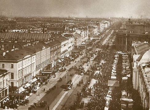
Bilbao is situated in the province of Bizkiai, Northern Spain and is considered the economical capital of the Basque region. (John Crowley, 2013) I could bring you through the entire history of Bilbao which is indeed an interesting one but for the purpose of this blog post, I’m going to fast forward to the 20th century when Bilbao was the economic powerhouse of the Basque Country. In 1900, the Euskalduna shipyards were founded where the largest company in Spain of this century located and was the result of the merger of several iron and steel businesses. However, after Bilbao went through their own version of “The Celtic Tiger” the iron and steel industry was hit badly towards the end of the century and the Euskalduna shipyards in 1988 were forced to close. As one can imagine, this was a huge blow for the residents and economy of the city, similar to that experienced in the Dublin Docklands discussed by Katie M!

“Around the globe during the 19th and 20th Centuries, many waterfront cities such as […] Bilbao […] developed [its] waterfronts for industrial purposes. However, as urban economies began to make a postindustrial transition, many of these once highly productive waterfront spaces went into decline and became redundant.” (Davidson, 2009)

“The massive industrial and trading complexes that once dominated urban waterfronts became landscapes of despair. As capital fled from urban waterfronts, the communities that were left behind often faced high unemployment, economic stagnation, and growing social problems.” (Davidson, 2009)

But the city of Bilbao took the hit in its stride. Instead of giving up, it was at this time that Bilbao underwent, to link back to my first blog post, a sort of Haussmannisation of its own. Originally a grotty city whose economy depended on shipping industry, a wave of redevelopment surged through the city in the 1980s in the form of urban infrastructure and material culture. A tragic flood that left much of the waterfront destroyed and the city in social and economic decline in 1983 was as much of a motivation than the closing of the shipyards. It essentially became a brownfield site. (Davidson, 2009, pp 215)

Careful planning had to be taken into consideration to rebuild Bilbao’s image. Physically the landscape has healed but the memories transcend generations. When the decision was made to rid the shipyard, all the families who were dependent on it economically (labor struggles exist to this day) organised many strikes to oppose this gentrification (this antagonistic relationship between civilians and police is evident through the graffiti on the streets). Bilbao is now a city of significant regeneration, reinvention and re-imagination. It seems that it doesn’t dwell too much nor depend on its past but alludes back to it through its urban infrastructure and material culture where modernity and tradition stand proudly side by side. The docklands have been remade into a postindustrial space where remnants of past activities now only exist in the form of postmodern pastiche, where quaysides support the balconies of luxury apartments and cranes exist as artifacts.

Image 1. Photo Credit: Jennifer Egan, April 2014

Image 1.1 Juxtaposition between the traditional architecture and the modern glass skyscrapers. Photo Credit: Jennifer Egan, April 2014

Image 1.1

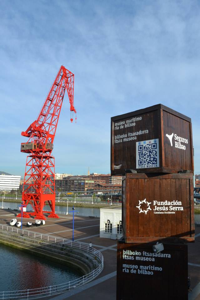
Image 1.2 A red Derek and stacked crates standing outside Bilbao Maritime Museum in remembrance of the city’s maritime heritage. The iOS codes are a modern twist. Photo Credit: Jennifer Egan, April 2014

Just off the Plaza del Saprado Coragon, Bilbao’s Maritime Museum acts as kind of a memorial site showcasing old boats and small ships shadowed by a red Derek/cranes, buoy structures as well as stacked crates that have iOS codes for iPhones (evidence of modernity and tradition merged). This is a bit off the beaten track and not obtrusive in the landscape. This may suggest that they humbly remember their past but choose to not let it dominate their present. Well, one might think that until they catch a glimpse of the new Euskalduna Conference Centre and Concert Hall located exactly where the shipyard originated. This is an extraordinary sight overlooking the waterfront. It’s rusty appearance imitates that of a ship being built. A new culture housed in an old one, one could say.

Image 1. Photo Credit: Jennifer Egan, April 2014

Image 1.3 Euskalduna Conference Center located down by the waterfront. The unique architecture of this building is reminiscent of Bilbao’s ship building past. Photo Credit: Jennifer Egan, April 2014

Apart from the aesthetic elements in this area, another thing that struck me is the high density of apartments that reach up to on average 5/6 stories along the waterfront. The planning department have gone to great lengths in catering for these apartment dwellers. Large public spaces are well-needed by the local residents of Bilbao to facilitate leisurely outdoor activities which they lack due to the fact apartments don’t generally come with a garden. These facilities are more than provided for in the form of running lanes, playgrounds, benches, roller skating rinks and greens. 

Image 1. Photo Credit: Jennifer Egan, April 2014

Image 1.4 Bilbao’s waterfront is a well planned public space providing areas for recreation, leisure, sport and retail for both residents and tourists. Photo Credit: Jennifer Egan, April 2014

 However the most significant feature of Bilbao’s waterfront is of course Frank Gehry’s Guggenheim which has become an iconic feature and huge draw for tourists. The design itself is reminiscent of steel and, for the visual culturist inside of me, an abstract resemblance of a ship sailing on waves. It’s a symbol of Bilbao’s past, present and possibilities.

Image 1. Photo Credit: Jennifer Egan, April 2014

Image 1.5 The most iconic building of Bilbao; The Guggenheim, designed by “starchitect” Frank Gehry. Is this a positive symbol of modernisation, or a sign that Bilbao has forgotten its roots? Photo Credit: Jennifer Egan, April 2014

I hear that its common practice in Hispanic countries for people to greet and part with a kiss, however due to the virtual circumstances, a humble muchos gracias and hasta la próxima will have to suffice!

Thanks to everybody who’s stuck with us, provided us with criticism and encouragement along the way! Everyone here at Drawing From The Archive’s hopes you’ve enjoyed it as much as we have!

Chau amigos!

Jennifer E | 112302041


Bibliography

All images are sourced from Jennifer Egan, April 1st – April 8th 2014.

Davidson, M. 2009 
‘Waterfront’ International Encyclopaedia of Human Geography, pp. 215-216.

Crowley, J. (2013) Case Study: Bilbao, [Lecture to BA Geography], GG2010: Geography of Tourism. University College Cork]. 

History of Bilbao‘, 2014, http://www.bilbaoturismo.net/BilbaoTurismo/en/hitos %5BAccessed 20th November 2014]

CORK AND ITS MARKETS – JENNIFER EGAN

Dowcha bai!

Excuse my (woeful) attempt at Corkonian, I’m afraid I’m not a native!

While I ventured abroad for my last blog post, I’ve decided to stay closer to home this week and delve into Cork’s past to explore it’s history of food retail and it’s markets, specifically during the 19th and early 20th centuries which for Cork, was an interesting period indeed. For the purpose of this blog, I’m going to hone in on The English Market, Cork Butter Market, St. Peter’s Market and street sellers down along the, as it’s colloquially known, Coal Quay. This week’s task requires us to create a story through digital photographs which surprisingly started out a little difficult with very few online archives storing many photographs of Cork’s markets.

“Still images can be moving and moving images can be still. Both meet within soundscapes.” ~ Chien-Chi Chang


The photograph of the Queen of England visiting The English Market took worldwide media by storm and became one of the most iconic photographs of the year. What was the reason for this? So what if Queen Lizzy visited the place I do some of my weekly shopping? This got me thinking of the importance of markets to Cork and it’s food-scene.

The economic prosperity of Cork grew in the 18th Century and was based primarily on the provisions trade; salted beef, pork, butter and the like were exported to the West Indies to provision the British navy. The unrivaled ability of Cork Harbour to shelter huge fleets was of course a major factor in the expansion of this type of trade. Cork Butter was internationally renowned and became the largest butter market in the world for its time because of this ability to export huge quantities of goods.

Image 1.1 Grand Parade entrance of The English Market with tramline passing outside.
Image 1.1 Grand Parade entrance of The English Market with tram-line passing outside. This perhaps provided transportation for those frequenting the market with their load of shopping. Sourced from Cork City and County Archives’ current exhibit named Cork:Merchant Heritage.

As well as being able to ship stuff out, huge cargo ships had easy access into Cork’s Harbour. It allowed exotic food stuffs such as spices from the East to be imported and sold to the people of Cork, or at least to the more affluent. With this, saw the opening of The English Market in 1788 as a flagship municipal market located at the heart of the new CBD (central business district for those less geographically inclined).

Image 1.1 This photo captures a moment on any given day in The English Market back in the 19th Century. Sourced from The English Market's archives.
Image 1.2 This photo captures a moment on any given day in The English Market back in the 19th Century. Photographer unknown. Sourced from The English Market’s archives.

This photo is very showing of the time as the majority of the people doing their shopping are in fact women and their children. Not only this, but they are very well dressed which perhaps is telling of their social class. Although the English Market was praised by many, it only served the prosperous. The less well off shopped in what was known as the Irish Market, St. Peter’s Market which had entrances on North Main Street and Cornmarket St. Food prices were more affordable here.

Image 1. St. Peter's Market Street Front. Sourced from Michael O'Leary Collection of Cork City Council Archives
Image 1.3 St. Peter’s Market Street Front c. 1900. Sourced from Michael O’Leary Collection of Cork City Council Archives.

Above is the shop front of St. Peter’s Market (where today lies the Bodega) which was completed in 1843. It was, in a way, the centerpiece of Cork’s market revolution. It was designed by the renowned architect Alexander Deane and modeled on St John’s Market in Liverpool, the largest in the U.K. Its hundreds of stalls sold meat fish and vegetables to the Cork working class. The quality of the food was below par with its grander counterpart, however the medieval town dwellers who enclosed their settlements with defensive walls greatly depended on the market for their supply of food and other necessities.

Image 1.4 Coal Quay, 1904. Sourced from The South...
Image 1.4 A bustling Coal Quay, 1904. See the difference of this bustling crowd compared to the desert St. Peter’s Market (no wonder it didn’t survive!) Sourced from The South of Ireland Illustrated with Descriptive Letterpress and Maps.
Image 1.  Roadside Butter Market Vendors, Cork. c. 1900
Image 1.5 Roadside Butter Market Vendors, Cork. c. 1900. Photographer unknown. Sourced from Cork City Libraries.

“The virtual porosity between the ‘covered street’ that was St Peter’s and the bustling real street outside down by Coal Quay (shown above) proved ultimately fatal to its prospects. It was never able to establish its own distinct, insulated identity as the English Market had done. While the latter continued to turn a healthy profit for the corporation, justifying continued expenditure on it and copperfastening its identity in the process, the Irish Market rapidly became a loss-maker. By early 1905  fifty-eight stalls in St Peter’s were vacant and its annual income of less than £500 was over £200 less than it had been the mid-1880s. Estimated expenditure on the market for 1906 was £600.” (http://www.englishmarket.ie, accessed on 01/11/2014)

In the mid 20th Century the remaining handful of stallholders in St Peter’s Market were given notice of eviction so to speak and were offered alternative pitches in The English Market. The Irish Market was no more. Present day Cork still enjoy weekly markets down by the Coal Quay and are invited to enjoy the creaminess of it’s once world famous butter at the Cork Butter Museum. The English Market is what cork is known for, it has been a symbol of the city since its opening welcoming both citizens and tourists alike to enjoy its very successful innovations and creations of artisan foods.


I guess that explains my question; I’m sorry I ever doubted the Queen’s decision to come visit!

Image 1.6 Queen with Pat
Image 1.6 Queen with Pat O’Connell of K O’Connell Fish. Sourced from The English Market’s archives.

I hope you’ve enjoyed your perusal of my blog installment this week, despite it not being as exotic as the others’! Keep your eyes peeled for next week when I get the opportunity to showcase some of my own photography skills.

Bye, bye, bye, bye, bye, bye, bye, bye…should I just stop trying to be so Cork while I’m ahead?

Jennifer | 112302041

Planning to read more offline? Download the ePub! Simples!


Bibliography

General History of The English Market. [ONLINE] Available at: http://www.englishmarket.ie/historygallery/thehistoryoftheenglishmarket/theemergenceanddevelopmentofmarketsincorkcity/. [Accessed on 01 November 2014]
Image 1.1 Cork City and County Archives’ online exhibition, Cork: Merchant Heritage.  [ONLINE] Available at: http://www.corkarchives.ie/merchantcity/home/retailheritage/. [Accessed on 01 November 2014]
Image 1.2 and Image 1.6 The English Market’s Online Archives [ONLINE] Available at: http://www.englishmarket.ie/historygallery/gallery/. [Accessed on 01 November 2014]
Image 1.3 Michael O’Leary’s Collection [ONLINE] Available at: http://www.corkpastandpresent.ie/mapsimages/corkphotographs/michaelolearycollection/. [Accessed on 01 November 2014]
Image 1.4 The South of Ireland Illustrated with Descriptive Letterpress and Maps.

Urban Transformation in Pittsburgh – Katie McKay

Hello and Welcome

For this week’s blog I plan to create a photo post (of sorts) on a process which characterized cities during both the nineteenth and twentieth century.

*Drum roll*

I will be examining the theme of cinema-going in the twentieth century, with a particular emphasis on the city of Pittsburgh which is located in the southwest of Pennsylvania. (CityTownInfo, 2014).

Katie McKay | 112417258


To start us off, the establishment of the cinema was an urban phenomenon. The cinema served as a multi-functional monument within society at the time; it became part of the landscape of the city. It provided a place of relaxation for all classes; ranging from labourers to the women of the house. While also serving as a learning medium for immigrants (Charney & Schwartz, 1995, p.5). It became a practice of modernity, an enhancer of your status and created a medium for forward thinking.

Blog 2 Pictures

Image 1.1: The Opening of the Oaks Theater in 1938. 1938; Oakmont Carnegie Library Archives; Source here.

In the words of Susan Sontag “a society becomes “modern” when one of its chief activities is producing and consuming images” (1977).

The opening of a cinema was a symbol that modernity had met the city and the above image (see image 1.1) illustrates the modernization which took place in Pittsburgh during the twentieth century (Linehan, 2014).

getimage-idx (3)

Image 1.2: Marquee of the Oaks Theater. 1945; Oaks Theater Image Collection; Source here.

Similarly, the dynamics of the cinema followed that of the original exhibition buildings, i.e. the culture of the threshold door disappeared as everyone was welcomed to come to the cinema, a place where class and status remained firmly at the door. The disappearance of the threshold door can be seen in the image above (image 1.2), there is no step that one has to take to enter the Oaks Theater, this symbolizes that this venue was not just a place where the middle and upper classes could go but a place where the working class were welcome too (Linehan, 2014). 

getimage-idx

Image 1.3: School Children Outside of the Oaks Theater in 1949; Oaks Theater Image Collection; Source here.  This image illustrates the importance of the cinema in the education system as it shows a group of school children on a trip to the cinema.

In the twentieth century, the cinema was a very important social space, with film seen as a very powerful educational tool (Swain, 2013: Linehan, 2014). The above image (see image 1.3) illustrates the importance of film in education, film was seen as a learning medium for children as it taught them both how to behave and be civil in society and of the lands of far away places. (Linehan, 2014).

getimage-idx (1)

Image 1.4: The Audience at the Oaks Theater.  This image depicts the excitement and popularity of the opening of the cinema here in Pittsburgh, created in people’s lives. The room is filled with people of all ages both young and old showing the diversity and acceptance these picture houses created.  November 18, 1938; Oaks Theater Image Collection; Source here.

Before the establishment of the cinema, people often felt trapped in the world they lived in. The cinema brought with it a sense of freedom for people – an escape from the world which they lived in (Linehan, 2014). The cinema brought pleasure to people’s lives, the happiness which it brought can be seen in the image above; see Image 1.4 (Mulvey, 1975). This image is from the opening night at the Oaks Theater and the excitement which the opening of a cinema in Pittsburgh created can be seen through the smiles on the audience’s faces.

getimage-idx (2)

Image 1.5: Opening Night at the Oaks Theater November 18th 1938; this image shows the lavish interior design of the Oaks Theater; art deco style flooring, advertisements illuminated on the walls. Oaks Theater Image Collection; Source here.

The final image captures the modernity which greeted people when they walked through the doors of the Oaks Theater in Pittsburgh. The cinemas and picture houses of the 19th and 20th century were palaces for the everyday man and women and a home of excitement and wonderment. The lasting effect of the cinema has survived all the way through to the 21st century; for us they are still places of action, romance and wonderment just like they were for the viewers at the Oaks Theater in Pittsburgh.

I hope you have enjoyed this week’s blog post.

Until next time, 

Katie M

Bibliography:

Charney, L. and Schwartz, V.R. (Eds). (1995) Cinema and the Invention of Modern Life. California: University of California Press.

CityTownInfo, (2014) CityTownInfo. Available at: http://www.citytowninfo.com/places/pennsylvania/pittsburgh [Accessed 6 November 2014]

Linehan, D. (2014) ‘The Apparatus of Desire: Cinema, Social Space and the Human Geographies of Modernity’. GG3043: Historical Geographies of the City. University College Cork. 6 November. 

Mulvey, L. (1975) Visual Pleasure and Narrative Cinema. Available at: http://imlportfolio.usc.edu/ctcs505/mulveyVisualPleasureNarrativeCinema.pdf [Accessed 7 November 2014]

Oakmont Carnegie Library Archives. (1938) The Opening of The Oaks Theater. Available at: http://images.library.pitt.edu/cgi-bin/i/image/image-idx?rgn1=ic_all;xc=1;g=imls;sort=dc_da;q1=cinema;size=20;c=hpicasc;c=hpicchatham;c=hpiccma;c=hpiccmnh;c=hpichswp;c=hpicmonroeville;c=hpicnpl;c=hpicoakmont;c=hpicphlf;c=hpicpitcairn;c=hpicpointpark;c=hpicpso;c=hpicrsc;c=hpicusc;back=back1415296131;subview=detail;resnum=2;view=entry;lastview=thumbnail;cc=hpicoakmont;entryid=x-20100512-ocl-0892;viewid=20100512-OCL-0892ED.TIF [Accessed 4 November 2014]

Oaks Theater Image Collection. (1938) The Audience at the Oaks Theater. Available at: http://images.library.pitt.edu/cgi-bin/i/image/image-idx?rgn1=ic_all;xc=1;g=imls;sort=dc_da;q1=cinema;size=20;c=hpicasc;c=hpicchatham;c=hpiccma;c=hpiccmnh;c=hpichswp;c=hpicmonroeville;c=hpicnpl;c=hpicoakmont;c=hpicphlf;c=hpicpitcairn;c=hpicpointpark;c=hpicpso;c=hpicrsc;c=hpicusc;back=back1415296131;subview=detail;resnum=4;view=entry;lastview=thumbnail;cc=hpicoakmont;entryid=x-20091215-ocl-0178;viewid=20091215-OCL-0178ED.TIF [Accessed 4 November 2014]

Oaks Theater Image Collection. (1938) Opening Night at the Oaks Theater. Available at: http://images.library.pitt.edu/cgi-bin/i/image/image-idx?rgn1=ic_all;xc=1;g=imls;sort=dc_da;q1=cinema;size=20;c=hpicasc;c=hpicchatham;c=hpiccma;c=hpiccmnh;c=hpichswp;c=hpicmonroeville;c=hpicnpl;c=hpicoakmont;c=hpicphlf;c=hpicpitcairn;c=hpicpointpark;c=hpicpso;c=hpicrsc;c=hpicusc;back=back1415296131;subview=detail;resnum=3;view=entry;lastview=thumbnail;cc=hpicoakmont;entryid=x-20091215-ocl-0177;viewid=20091215-OCL-0177ED.TIF [Accessed 4 November 2014]

Oaks Theater Image Collection. (1945) Marquee of the Oaks Theater. Available at: http://images.library.pitt.edu/cgi-bin/i/image/image-idx?rgn1=ic_all;xc=1;g=imls;sort=dc_da;q1=cinema;size=20;c=hpicasc;c=hpicchatham;c=hpiccma;c=hpiccmnh;c=hpichswp;c=hpicmonroeville;c=hpicnpl;c=hpicoakmont;c=hpicphlf;c=hpicpitcairn;c=hpicpointpark;c=hpicpso;c=hpicrsc;c=hpicusc;back=back1415385643;subview=detail;resnum=7;view=entry;lastview=thumbnail;cc=hpicoakmont;entryid=x-20091215-ocl-0181;viewid=20091215-OCL-0181ED.TIF [Accessed 7 November 2014]

Oaks Theater Image Collection. (1949) Schoolchildren Outside of the Oaks Theater. Available at: http://images.library.pitt.edu/cgi-bin/i/image/image-idx?rgn1=ic_all;xc=1;g=imls;sort=dc_da;q1=cinema;size=20;c=hpicasc;c=hpicchatham;c=hpiccma;c=hpiccmnh;c=hpichswp;c=hpicmonroeville;c=hpicnpl;c=hpicoakmont;c=hpicphlf;c=hpicpitcairn;c=hpicpointpark;c=hpicpso;c=hpicrsc;c=hpicusc;back=back1415296131;subview=detail;resnum=8;view=entry;lastview=thumbnail;cc=hpicoakmont;entryid=x-20091215-ocl-0180;viewid=20091215-OCL-0180ED.TIF [Accessed 4 November 2014]

Sontag, S. (1977) ‘Photography Unlimited’, The New York Review of Books, 23 June. Available at http://www.nybooks.com/articles/archives/1977/jun/23/photography-unlimited/ [Accessed 6 November 2014]

Swain, H. (2013) ‘Film can have a leading role in education’, The Guardian, 19 November. Available at: http://www.theguardian.com/teacher-network/2013/nov/19/film-education-learning-tool-inclusion [Accessed 7 November 2014]

Boston and ‘the spectacle’ – Katie O’Sullivan

Hey there!

Throughout the course of this week’s blog post I hope to present an informative interpretation of urban life in early 20th Century Boston, Massachusetts.  Photography is intrinsic to our understanding of historical geography. Surveying the city in the early days of photography produced images used for educational or decorative purposes (Dennis 55). To the keen geographer in modernity however, they provide us with a record which we can analyse and interpret.

I will specifically be focusing on the idea of the spectacle and how spaces were provided for this using Franklin Park Zoo and Fenway Park as examples. Crowd engagement with celebrity has also proved to be a powerful political, cultural, economic and social tool and I will use Amelia Earhart and Babe Ruth to show this.

Compiled Map Points

Map 1.1: A quick illustration I mapped out using Google Earth to show where Images 1.2, 1.3 and 1.4 were taken. I have also roughly outlined Greater Boston.

You can click here for further online materials.

New York’s World Fair in 1935 opened with the slogan ”Dawn of a New Day” and encouraged visitors to embrace ”the world of tomorrow”. Exhibitions such as this were commonplace in the 19th and 20th centuries (starting in London’s Hyde Park) and these could be considered the beginnings of the spectacle on a large scale in the everyday urban environment.

Katie O’Sullivan | 112362596


Boston. (Arthur Griffin c.1935-55)

AG1

Image 1.1: Housed in Griffin Museum of Photography. Series: Boston Winter A. Filed under: Gelatin Silver Prints (8 x 10 in.) This aerial shot gives a good impression of Boston at this time. Faneuil Hall is centered (the  building extends past the dome), giving due importance to the longtime meeting hall and marketplace ( est. 1742)

Brown bear takes a bath at Franklin Park Zoo. (Leslie Jones c. 1917-34)

LJ4

Image 1.2: Housed in the Boston Public Library. Series: Animals: Franklin Park Zoo. Filed under: Glass negatives (4 x 5 in.) This is a terrific image showing how  animals forego their wild instinctive nature in favour of a passive human one when in captivity. It is also an interesting take on the idea of surveillance and who is really watching who, as the bear gazes directly out at us.


A zoo is at once, both a form of containment and display, inviting spectators to wander a 72-acre site, no matter the season. By putting wild animals in enclosures humankind has essentially reshaped nature (see Image 1.2). Even today, the zoo as a form of entertainment has not lost its popularity. It is easy to imagine how intimidating and exciting it was for children and adults to be so near to exotic animals they may never have otherwise encountered in 1912 when the Zoo opened. Zoos were also educational, teaching the general public about the geographical origins of the animals and their habitats, creating a more knowledgeable society.


  Amelia Earhart at East Boston Airport in Ford Trimotor (Leslie Jones c. July 1920**)

LJ3

Image 1.3: Housed in the Boston Public Library. Series: Aviation: Boardman, Earhart & Grayson. Filed under: Glass negatives (4 x 5 in.) Before the aeroplane became a common mode of transport across the globe, one can only imagine the ‘wow’ factor at seeing someone fly; fast and high. It should be noted that  there is a relatively heavy security presence around the crowd and a group of Native Americans at the top left; showing how Amelia was held in high esteem by a diverse range of people; men and women alike.


I came across countless photos of new technology and transport methods in the archives. However, I chose this particular one (see Image 1.3)  as it demonstrates the celebrity combined with air transport. It is ironic that Jervis states ‘such machines [aeroplanes were] characteristically coded as masculine’ (1998, p. 213). Following on from this, we discussed how the role of women has changed over the centuries in lectures this week. This makes Amelia Earhart all the more special as she too became an icon, a female aviator enshrouded in success and mystery, disappearing 10 years after this visit to the grounds that later became Logan Airport.


 Babe Ruth autographing at Fenway. (Leslie Jones c. 1934) 

LJ2

Image 1.4: Housed in the Boston Public Library. Series: Baseball. Filed under: Glass negatives (4 x 5 in.) As a fan of rugby myself, I can relate to the youths in this image who yearn for a souvenir that can last a lifetime. This relationship is intrinsic as an autograph on a ball or jersey can be handed down in family history with the accompanying story  ”I remember when I met Babe Ruth after that spectacular game …” as well as being of sentimental or even economic value.


Without the infrastructure of a park or stadium in which to practice and play competitively, baseball may never have taken off as a national sport. Fenway Park is iconic and the oldest Major League Baseball (MLB) park still in use (see Image 1.4). 1903 brought with it the first world series in the MLB as the Boston Americans (renamed the Red Sox in 1907) beat the Pittsburgh Pirates. Their early successes generated a large fan-base. It’s interesting to note that the fans Babe Ruth is attending to in the image are male. This shows the gender division in sports at the time.


State House fireworks. (Leslie Jones c. 4th July  1932)

LJ 1

Image 1.5: Housed in the Boston Public Library. Series: Boston: Public Buildings. Filed under: Glass negatives (4 x 5 in.) This image is the very pinnacle of  how most people would regard ‘the spectacle’; a fireworks show. However, there are politics of prestige and power involved in the organisation of such displays. This one for instance is held near the State House.

  Jervis defines the spectacle as ‘an extravagant visual entertainment… [which] dramatizes and projects the passivity of experience, its dependence on canons of representation through which its meaning is shaped and defined’ (1998, p. 344).

To conclude, the growth of celebrity and success in sport kept the public in good spirits. Meanwhile an increase in outdoor family activities, celebrating Independence Day and trips to the Zoo helped reduce potential dissention. These public events, whereby people were regulated through spectating, became a kind of safety valve, a common conclusion among political historians. The diverse range of spectacles pictured above, acted as an underhanded method of regulating Bostonians and will last infinitely through the medium of photography.

That’s all for this week,

Katie O.


** The archival record date for Image 1.3 is incorrect as this was before Amelia became well known and admired, it is more likely to have been c. 1927-28


 Bibliography.

See History | Sports and Leisure at <http://www.cityofboston.gov/visitors/about/trivia.asp&gt;

Dennis, R 2008, Cities in modernity, Cambridge University Press, UK.

Jervis, J 1998, Exploring the Modern, Blackwell Publishing, UK.

Montréal, Canada – Pierre-Joseph Cancellieri

Bonjour et bienvenue

For this week’s blog, I decided to examine an urban infrastructure project which was created in the city of Montréal during the 20th century.  In order to give you all a better idea of the city which existed in the 20th century, here is a few facts; Montréal is located on the biggest island of the Hochelaga archipelago on the Saint Lawrence river, in Québec, Canada. Downtown Montréal is on the South bank of the island, and trapped between the river and a mountain called Mount Royal.

Throughout this blog post, we will explore the construction of the tunnel,  first how it was mined through the mountain and then examine the by product effects it had on the people of Montréal, with special recognition to the creation of a new city to the north of the tunnel.

I was lucky enough to spend a year living in Montréal in 2012, so I found this week’s task incredibly interesting, it allowed me to step back in time into back to a city, which I once experienced on a daily basis! I hope you enjoy reading this post,  as much as I had creating it!

Stay tuned to learn some really interesting facts, especially relating to the power a successful urban infrastructure can create !

Pierre-Joseph Cancellieri | 114 112 124


Map 1.1 : This map illustrates the proposed plan of the tunnel, downtown Montréal and Mount Royal town.

First, we will examine a description of the project,  its effects on the city, its inhabitants and its geography. Finally, we’ll explore the difficult reality which revolved around the construction of the tunnel.

The tunnel is built under Mount Royal, a mountain which dominates the island of Montréal. Because of a fierce competition of railways companies during the early 20th century, the Canadian Northern Railways (CNR) decided to built a tunnel to compete with other railways owned by competing companies.

View of the work under Mount Royal. Fuel engines weren't used a lot because of the smoke and the lack of ventilation in the tunnel

Image 1.1: This image illustrates the work which was occurring under Mount Royal. At the time fuel engines were not frequently used due to amount of smoke produced and the lack of ventilation in the tunnel.

Due to a technical challenge, workers mostly used pickaxe and horses to dig out the rocks

Image 1.2 : Due to a lack in technological advances, workers mostly used pickaxes and horses in order to to mine the mountain; to create the tunnel.

It was a huge project, it created both a technical and financial challenge for CNR, so in order to make it profitable, they decided to create a new city based on E. Howard’s theory (Garden City). This new city would benefit from the creation of the tunnel acting as a commuter tunnel and rail system. Indeed, we can sum up the garden city model has an suburban city connected by railways line to the inner city. The train station and the commercial area are located in the centre of the garden city. Houses are around the center and they are surrounded by green fields which provide food for the city.

 ( In the bibliography, you will find two links which will provide more information on the Garden city model.) 

Town of Mount Royal in 1927, we can see the railways line, the station in the middle and an efficient streetscape to connect all part of the new city to the station

Image 1.3: This aerial photographs gives the clear picture of the town of Mount Royal (TMR) in 1927, we can clearly identify the railways lines, the station in the middle of the image and an efficient streetscape which connected the city to the station.

On the topic of the actual geography of the city, the tunnel created the same effect as if they had completely removed the mountain.  It successfully facilitated reliable transport to the north of downtown Montréal; the availability of free flowing public transport in Montreal had been transformed. With the construction of the tunnel, residential suburbs and commuters were born.

However, during its creation the tunnel faced huge difficulties. First, the Great War which destroyed mainland Europe, slowed the progress of the tunnel’s creation due to lack in the availability of resources. In 1918, when the first train set off, no ceremony celebrating its maiden journey was held due to the widespread effect of the public disease; The Spanish Flu. Unfortunately, not long after this the the company faced a financial low; mass debt threatened the company’s status and with this the tunnel’s  use. As a last resort, the company was nationalized in 1923. Following on from that, the rising rates of car sales further reduced the potential of the tunnel.

Even if the tunnel was a financial disaster for CNR, the town of Mount Royal grew and became a model city in all aspects, in its design but also in its character.

a model city in all aspects, clean roads, well dressed people, nice cars and beautiful house. In the 30's and 40's, the city was dwelled by English speaking upper class of Montréal's urban area

Image 1.4: Montreal became a model city. It was a city which was transformed; decked out with an efficient road system and examples of wealth such as expensive cars and lavish suburban homes. Interestingly, in the 1930’s and 1940’s, the city’s urban areas were home to the English speaking upper class of Montréal society. 

Nowadays, it still exists as a wonderful tool to the city of Montréal.  While built in the early 20th century, the tunnel is still  providing efficient transportation between the North and downtown Montréal.

Skyview of town Mount Royal, nowadays. Certain ideas of E. Howard have been respected such as green spaces, we can see the difference between TMR and its environment

Image 1.5: This aerial image shows the town of Mount Royal nowadays. You can clearly identify how certain ideas proposed by E. Howard have been respected due to the abundance of green spaces, this image allows us to identify the difference between TMR and its surrounding environment.

To conclude, despite the fact that car usage still remains a predominant method of private transportation in terms of commute, the town of Mount Royal retains its strong link with the tunnel.  The tunnel is the epitome of the town’s heritage, it led to its creation and subsequent success as a suburban town. In 2012 the people of Montreal honored the hundredth anniversary of the beginning of the tunnel’s drilling and creation of the town of Mount Royal; a city built beyond the original boundaries.

I hope you have enjoyed discovering the important role of urban infrastructure in the city of Montreal.

Until next week!

Pierre

Bilbliography

link 1

link 2

Sources: click here

Saint Petersburg, Russia – Aoife Cotter

” Dobro pažálovat’ “

Hello and welcome to the week’s last blog post; I hope you all have thoroughly enjoyed perusing through this week’s batch of posts!

Last week I examined the regeneration of London after The Great Fire of 1666, this week I have decided to explore the main thoroughfare of the city of Saint Petersburg, Russia; circa the early 20th century. I hope the post will give you a better understanding of main street urban infrastructure as an important public space during this period.

Aoife Cotter | 112495138


Today, Saint Petersburg is filled with rich history and culture, an unusual feat for such a young city of just three hundred years old. The city itself is built upon the banks of the Neva River. Founded in 1703 by Tsar Peter the Great (1682-1721) as his capital; the city remained the capital of the Russian Empire until the Russian Revolution of 1917.

In the late 19th century, Saint Petersburg was thriving. As capital, it was home to state officials, the military garrison and the imperial court. Its unique and dramatic architecture was the equal of any other European city of the time. Buildings such as the Winter Palace now known as the State Hermitage Museum, were representative of a lavish and thriving capital. Saint Petersburg was fast becoming a capitalist city. The effects of industrialization were evident as foreign and national factories grew rapidly within the city’s environs and banks and various other companies made Saint Petersburg their home.

Map 1.1 – A map of Saint Petersburg in 1720.  The map depicts the development of the city was only created fifteen years earlier. The map was created by Johann Baptiste Hommann

Map 1.1 – Johann Baptiste Hommann’s map of Saint Petersburg circa 1720.
This map depicts the development of the city which was created fifteen years earlier.

The Nevsky Prospect was created at Peter the Great’s behest as the boulevard which would be the main artery to the ancient city of Novgorod but quite quickly became the main street of the city, a city named in honor of Saint Peter. The street itself was named after a 13th century war hero, Alexander Nevsky. Saint Petersburg’s main shops and businesses are located on and around this grand thoroughfare. The Nevsky Prospect, from humble beginnings, has now become Peter’s lasting legacy to the city’s physical infrastructure and its people.

Image 1.2 – The Nevsky Prospect 1912. This digital photography clearly illustrates the . The availability of photographic equipment due to techonological advances in the early 19th century allowed for this image to be produced. This image illustrates a clear picture of Saint Peterburg’s citizens using the Nevsky Prospect in their daily lives.

Image 1.1 – The Nevsky Prospect, 1912. This digitalized photograph clearly illustrates the bustling main street and demonstrates Saint Petersburg’s citizens’ use of the Nevsky Prospect in their daily lives.

The Nevsky Prospect continued to evolve throughout the years. In the early years of the 20th Century, the addition of a public light infrastructure and improvements to accessibility, such as new bridges over Neva River, made the Nevsky Prospect a more inviting and accessible public space. In addition to the Winter Palace, the Prospect is home to some outstanding architectural and imposing buildings such as the Kazan Cathedral, the Gostiny Dvor building and The Church of Our Saviour on Spilled Blood which was completed in 1907.

Nevsky Prospect View

Image 1.2 – A vintage postcard from 1906 illustrates a view of the Winter Palace from the corner of the Nevsky Prospect. This image represents just one of many architectural and historical sites which are situated on the Prospect.

These landmarks enhance the overall experience of the Prospect, they complement the existing buildings of the street  which are uniform in nature.

“In the words of the poet Piotr Viazemsky, “slender, regular, aligned, symmetrical, single-colored…””

The Nevsky Prospect

Image 1. 3 – The Nevsky Prospect; circa 1910. This image clearly illustrates the Prospects success and popularity as a main street in the early 20th century and demonstrates the uniformity of the streetscape architecture.

Today, the Nevsky Prospect still exists; it is the city’s central shopping street and the hub of the city’s entertainment and nightlife. It still possesses the same function, it did in the centuries before; acting as a place of promenade for citizens and tourists alike.

“‘Public space’’ is the space where individuals see and are seen by others as
they engage in public affairs” – (James Mensch, 2007)

While the Nevsky Prospect is not a public place of recreation, it is a public space of importance and innovation as a functioning main street. In the late 19th and 20th centuries, it was the city’s central hub of activity, a space that allowed business and trades to thrive. Its significance and success as a crucial urban structure is supported by historic photographic evidence, some of which is included above.

Untitled

Image 1.4 – The Nevsky Prospect circa the early 1990’s. This image is yet again another representation of the avenues success in the early 20th century.

Image 1.4 - The Nevsky Prospect; modern day. Its function in society has not changed since its creation.

Image 1.5 – The Nevsky Prospect; modern day. Its function in society has not changed since its foundation.

While, the other contributors to this blog have examined various other processes which occurred in cities throughout the 19th and 20th century.  I firmly believe in the importance of public space. The utilization of public spaces has been established for centuries and many historic public spaces continue to act as hubs of activity in today’s society. The Nevsky Prospect is a perfect example of such a functional public space; it provides both a platform and focus for the city’s daily operations and interactions and facilitates its citizens and tourists alike.

And with that concluding sentence, I bring this week’s blog posts to a close.

Be sure to stay tuned for next week’s blog!

From Russia with love,

Aoife

Bibliography

The Facts of Saint Petersburg – Available at: http://www.saint-petersburg.com/quick-facts.asp[Accessed 21st October 2014]

Saint Petersburg History – Available at: http://www.saint-petersburg.com/history/introduction.asp [Accessed 21st October 2014]

Saint Petersburg History – Available at: http://saint-petersburg-russia.org/st-petersburg-19th-century [Accessed 21st October 2014]

Nevsky History – Available at:http://nskrip1.blogspot.ie/2012/11/the-history-of-nevsky-prospect-in-st.html [Accessed 21st October 2014]

1720 Map – Available at: http://www.raremaps.com/gallery/detail/31239/Topographische_Vorstellung_der_Neuen_Russischen_HauptResidenz_und/Homann.html [Accessed 21st October 1014]

“Public Space” James Mensch 2007-03-01o Continental Philosophy Review

Available at: http://0-link.springer.com.library.ucc.ie/article/10.1007/s11007-006-9038-x [Accessed 21st October 2014]