Saint Petersburg, Russia – Aoife Cotter

” Dobro pažálovat’ “

Hello and welcome to the week’s last blog post; I hope you all have thoroughly enjoyed perusing through this week’s batch of posts!

Last week I examined the regeneration of London after The Great Fire of 1666, this week I have decided to explore the main thoroughfare of the city of Saint Petersburg, Russia; circa the early 20th century. I hope the post will give you a better understanding of main street urban infrastructure as an important public space during this period.

Aoife Cotter | 112495138


Today, Saint Petersburg is filled with rich history and culture, an unusual feat for such a young city of just three hundred years old. The city itself is built upon the banks of the Neva River. Founded in 1703 by Tsar Peter the Great (1682-1721) as his capital; the city remained the capital of the Russian Empire until the Russian Revolution of 1917.

In the late 19th century, Saint Petersburg was thriving. As capital, it was home to state officials, the military garrison and the imperial court. Its unique and dramatic architecture was the equal of any other European city of the time. Buildings such as the Winter Palace now known as the State Hermitage Museum, were representative of a lavish and thriving capital. Saint Petersburg was fast becoming a capitalist city. The effects of industrialization were evident as foreign and national factories grew rapidly within the city’s environs and banks and various other companies made Saint Petersburg their home.

Map 1.1 – A map of Saint Petersburg in 1720.  The map depicts the development of the city was only created fifteen years earlier. The map was created by Johann Baptiste Hommann

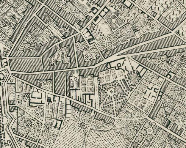
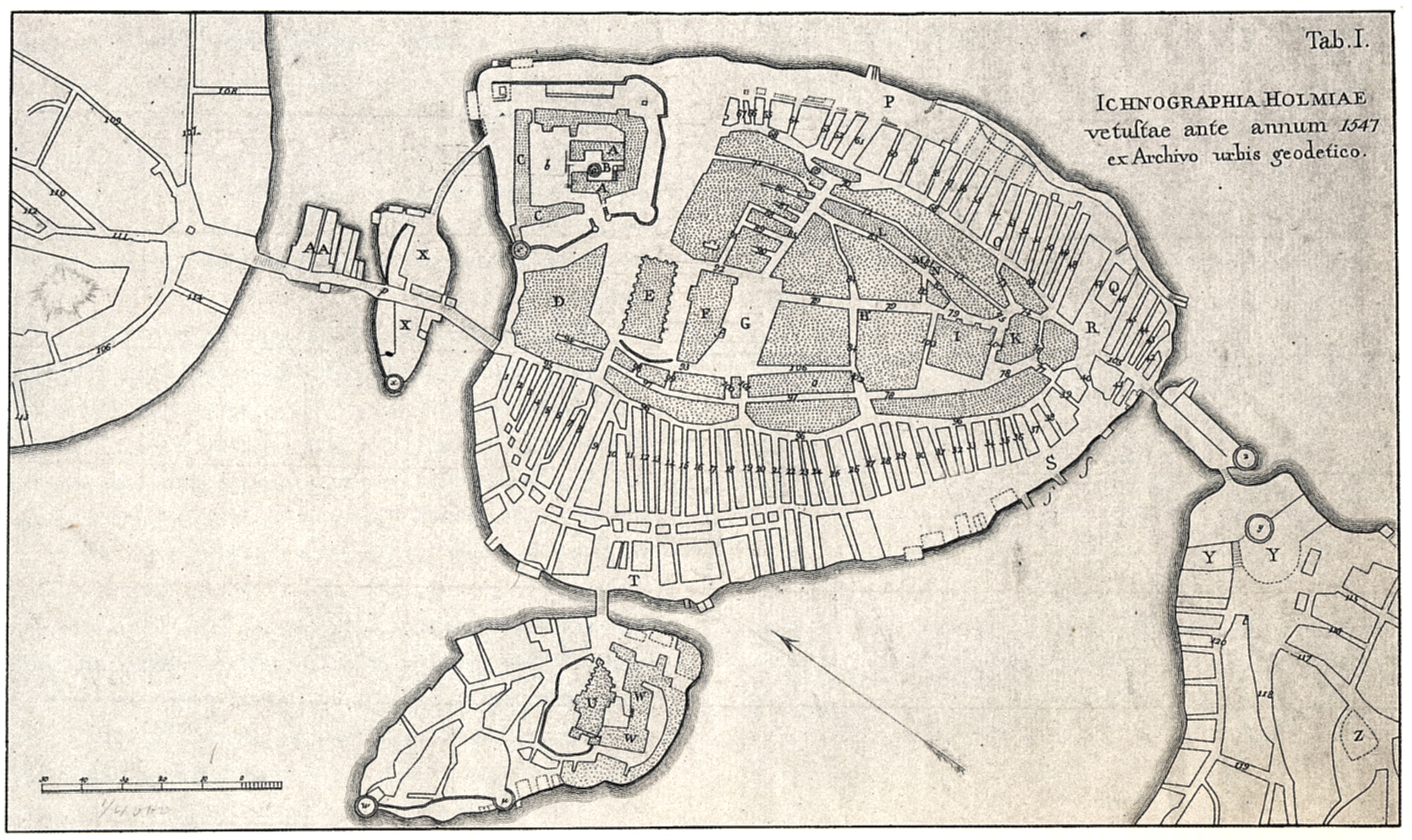
Map 1.1 – Johann Baptiste Hommann’s map of Saint Petersburg circa 1720.
This map depicts the development of the city which was created fifteen years earlier.

The Nevsky Prospect was created at Peter the Great’s behest as the boulevard which would be the main artery to the ancient city of Novgorod but quite quickly became the main street of the city, a city named in honor of Saint Peter. The street itself was named after a 13th century war hero, Alexander Nevsky. Saint Petersburg’s main shops and businesses are located on and around this grand thoroughfare. The Nevsky Prospect, from humble beginnings, has now become Peter’s lasting legacy to the city’s physical infrastructure and its people.

Image 1.2 – The Nevsky Prospect 1912. This digital photography clearly illustrates the . The availability of photographic equipment due to techonological advances in the early 19th century allowed for this image to be produced. This image illustrates a clear picture of Saint Peterburg’s citizens using the Nevsky Prospect in their daily lives.

Image 1.1 – The Nevsky Prospect, 1912. This digitalized photograph clearly illustrates the bustling main street and demonstrates Saint Petersburg’s citizens’ use of the Nevsky Prospect in their daily lives.

The Nevsky Prospect continued to evolve throughout the years. In the early years of the 20th Century, the addition of a public light infrastructure and improvements to accessibility, such as new bridges over Neva River, made the Nevsky Prospect a more inviting and accessible public space. In addition to the Winter Palace, the Prospect is home to some outstanding architectural and imposing buildings such as the Kazan Cathedral, the Gostiny Dvor building and The Church of Our Saviour on Spilled Blood which was completed in 1907.

Nevsky Prospect View

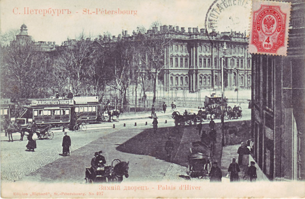
Image 1.2 – A vintage postcard from 1906 illustrates a view of the Winter Palace from the corner of the Nevsky Prospect. This image represents just one of many architectural and historical sites which are situated on the Prospect.

These landmarks enhance the overall experience of the Prospect, they complement the existing buildings of the street  which are uniform in nature.

“In the words of the poet Piotr Viazemsky, “slender, regular, aligned, symmetrical, single-colored…””

The Nevsky Prospect

Image 1. 3 – The Nevsky Prospect; circa 1910. This image clearly illustrates the Prospects success and popularity as a main street in the early 20th century and demonstrates the uniformity of the streetscape architecture.

Today, the Nevsky Prospect still exists; it is the city’s central shopping street and the hub of the city’s entertainment and nightlife. It still possesses the same function, it did in the centuries before; acting as a place of promenade for citizens and tourists alike.

“‘Public space’’ is the space where individuals see and are seen by others as
they engage in public affairs” – (James Mensch, 2007)

While the Nevsky Prospect is not a public place of recreation, it is a public space of importance and innovation as a functioning main street. In the late 19th and 20th centuries, it was the city’s central hub of activity, a space that allowed business and trades to thrive. Its significance and success as a crucial urban structure is supported by historic photographic evidence, some of which is included above.

Untitled

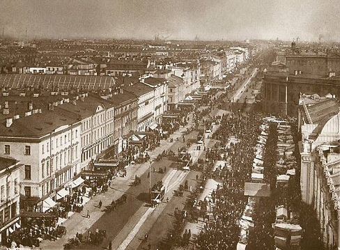
Image 1.4 – The Nevsky Prospect circa the early 1990’s. This image is yet again another representation of the avenues success in the early 20th century.

Image 1.4 - The Nevsky Prospect; modern day. Its function in society has not changed since its creation.

Image 1.5 – The Nevsky Prospect; modern day. Its function in society has not changed since its foundation.

While, the other contributors to this blog have examined various other processes which occurred in cities throughout the 19th and 20th century.  I firmly believe in the importance of public space. The utilization of public spaces has been established for centuries and many historic public spaces continue to act as hubs of activity in today’s society. The Nevsky Prospect is a perfect example of such a functional public space; it provides both a platform and focus for the city’s daily operations and interactions and facilitates its citizens and tourists alike.

And with that concluding sentence, I bring this week’s blog posts to a close.

Be sure to stay tuned for next week’s blog!

From Russia with love,

Aoife

Bibliography

The Facts of Saint Petersburg – Available at: http://www.saint-petersburg.com/quick-facts.asp[Accessed 21st October 2014]

Saint Petersburg History – Available at: http://www.saint-petersburg.com/history/introduction.asp [Accessed 21st October 2014]

Saint Petersburg History – Available at: http://saint-petersburg-russia.org/st-petersburg-19th-century [Accessed 21st October 2014]

Nevsky History – Available at:http://nskrip1.blogspot.ie/2012/11/the-history-of-nevsky-prospect-in-st.html [Accessed 21st October 2014]

1720 Map – Available at: http://www.raremaps.com/gallery/detail/31239/Topographische_Vorstellung_der_Neuen_Russischen_HauptResidenz_und/Homann.html [Accessed 21st October 1014]

“Public Space” James Mensch 2007-03-01o Continental Philosophy Review

Available at: http://0-link.springer.com.library.ucc.ie/article/10.1007/s11007-006-9038-x [Accessed 21st October 2014]

THE CITY OF LIGHT AND ITS BOULEVARDS – Jennifer Egan

Bonjour et Bienvenue!

“You can’t escape the past in Paris, and yet what’s so wonderful about it is that the past and present intermingle so intangibly that it doesn’t seem to burden.” -Allen Ginsberg

For this week’s blog entry, I’ve decided to be self-indulgent and use it as an excuse to learn more about, and to then share with you, my favourite city, Paris. To date, I’ve been lucky enough to see some awe-inducing parts of the world, but none are quite like the French capital of Paris that has been hollowed and re-fashioned by history. As one walks through her boulevards, you’re captivated by something new at every corner, but it’s the seamless juxtaposition between the old and new that is most brilliant.


This week I shall be focusing on the modernizing of Paris during the Age of Enlightenment. I intend on doing this by comparing, with the aid of digital maps, pre and post Baron Haussmann’s endeavor to undertake one of the largest urban regeneration projects since the burning of London in 1666 which you can read more on in Aoife’s first installment.

Haussmann’s radical project included such things as an expanded sewer system, gas lighting for the streets, a uniform facade for the city’s building, construction of new parks and the division of Paris into arrondissements. However, for the purpose of this blog, I shall focus in on the construction and reorganization of boulevards across the city. “Think about Paris and sooner, rather than later, the word boulevard will come to mind. Boulevards – the word itself, perhaps as much as their physical reality – define this city. The word conjures up images of broad tree-lined sidewalks, elegant building, attractive stores, corner cafes, crowds of people, and the warm light of street lamps.” (Jacobs, McDonald & Rofé, 2003)

Image of The Avenue des Champs-Élysées which is a boulevard in the 8th arrondissement of Paris, 1.9 kilometres long and 70 metres wide, which runs between the Place de la Concorde and the Place Charles de Gaulle, where the Arc de Triomphe is located. The grandeur and width of this boulevards and nicely complimented by the manicured trees and large open spaces at the end of each boulevard.


Fig. 1: A Plan of the City of Paris, 1800. Source here.

As seen in the map above, the streets used to be narrow, chaotic and disorderly, leading to everywhere and nowhere. The tight confines of medieval Paris were hindering the city’s potential for growth and its desire to transform into a well-organized, modern urban hotspot. Modernity’s urban signature was seen as one of order, power and transformation. For Napolean III, that is exactly what he wanted to gain over the Parisiennes: control; boulevards were a physical representation of just that. Although many people at the time argued that the sole motivation for the construction of these boulevards was a strategic move by Napolean III and his military, Paris urban historian Patrice de Moncan wrote: “To see the works created by Haussmann and Napoleon III only from the perspective of their strategic value is very reductive. His desire to make Paris, the economic capital of France, a more open, more healthy city, not only for the upper classes but also for the workers, cannot be denied, and should be recognised as the primary motivation”. They were the places to see and be seen; lined with opulent boutiques, café bistros and hand-manicured trees. They were places where affluence could be flaunted and admired, and where, thanks to the new water and sewer systems, citizens could show off their new found cleanliness.

Blog One - Old Boulevards            Blog One New Boulevards
Fig. 2: Snippet of Map of Paris, 1800. Source here.         Fig. 3: Snippet of Map of Paris, 1889. Source here.

Even though it’s quite hard to believe, Fig. 2 and Fig. 3 are of the same location in Paris, just west of the Ile de la Cité. This contrast between the 1800 and 1889 maps illustrates the extent of Haussmann’s transformation of the city’s street-scape over a mere time-span of twenty years with examples such as Boulevard du Temple and Boulevard de Ménilmontant shown in Fig. 3.

 File:Paris-cite-haussmann.jpg
Fig. 4: “Before Haussmann” Map of Ile de la Cité,   Fig. 5: “After Haussmann” Map of Ile de la Cité,
Paris. Source here.                                                  Paris. Source here.

Another visually striking contrast of pre and post regeneration evident on the Ile de la Cité with the development of wide, traverse roadways across the island joining the two bank of the Seine.

The revamping of Paris’ streets into boulevard was, I believe, an integral part of bringing the City of Light out of the Dark Ages and into the Modern era.


Thanks for tuning in this week and sticking with me! Hope you’ve enjoyed my very first blog post, as well as the others!

Jennifer E. | 112302041

Planning on doing some offline perusing? Download the ePub!

References

Fig. 1, Fig. 2, Fig. 3 – Old Maps of Paris. [ONLINE] Available at: http://www.oldmapsofparis.com/. [Accessed 15 October 14].
Fig. 4, Fig. 5 – Ile de la Cité transformation. [ONLINE] Available at: http://commons.wikimedia.org/wiki/File:Paris-cite-haussmann.jpg. [Accessed 15 October 14].
Jacobs A. B, McDonald E. and Rofé Y, 2003. The Boulevard Book: History, Evolution, Design of Multiway Boulevards. MIT Press.
de Moncan P., 2002. Le Paris d’Haussmann, p. 34.
General information on Haussmann’s plans. Available at: http://www.arthistoryarchive.com/arthistory/architecture/Haussmanns-Architectural-Paris.html [Accessed 12 October 14].

Edinburgh – Katie McKay

Ceud mìle fàilte!

The task for this week’s blog is to use digital maps to illustrate the growing influence of modernity in a city of your choice. In order to complete this task, I will look at two maps of Edinburgh, one of which is from the eighteenth century and the other which is from the nineteenth century.

Katie McKay | 112417258


Edinburgh is the capital of Scotland and today it is described as being “one of the most distinctive and widely recognised cities in the world” (Undiscovered Scotland, 2014). However, the distinctive and widely recognisable city of Edinburgh that can be seen today differs from that of eighteenth century Edinburgh.

Map 1.1: Plan of the City of Edinburgh in 1764

John_Rocque_Plan_von_Edinburgh_1764

Creator: John Rocque. Source: http://www.commons.wikimedia.org The above map illustrates Edinburgh’s streetscape before James Craig’s grid pattern plan for the north of the city was implemented.

In the early eighteenth century, Edinburgh was an overcrowded city and in order to accommodate the population, the city was crammed with tenement buildings, thus resulting in very narrow streets in Edinburgh city (see map 1.1) (Nenadic, 2011). The modernisation of the city did not begin until the collapse of a tenement building in 1751. As a result of the tenement collapse and the dissatisfaction with the conditions in the Old Town, there was an extension to the north of the city in the 1760s which was planned to James Craig’s grid pattern system (see map 1.2) (Undiscovered Scotland, 2014).

Map 1.2: Plan of the City of Edinburgh in 1820

Blog 1 image

Creator: John Woods. Source: http://www.maps.nls.uk The above map illustrates the growing influence of modernity in the city.

 In contrast to the 1764 map of Edinburgh (see map 1.1), the growing influence of modernity in the city can be seen in the map from 1820, the influence of modernity is visible through the public squares and boulevards in the map (see map 1.2). The use of a grid pattern of public squares and boulevards illustrates how the relationship between the buildings and their surroundings were predetermined; the use of grid patterns in the planning of a city highlights the growing influence of modernity in the city.

I’ll finish this week’s blog entry with a quote from the Edinburgh World Heritage website;

“The plan seems elegantly simple but it took Edinburgh from being the medieval ‘Auld Reekie’ of the past to the grandeur and classical style of the city as ‘Athens of the North’.”

That is all for this week,

Katie M

Bibliography:

Edinburgh World Heritage. (n.d.) The New Town Plan. Available at: http://www.ewht.org.uk/learning/Athens/the-new-town-plan [Accessed 16 October, 2014]

Nenadic, S. (2011) The Rise of Edinburgh. Available at: http://www.bbc.co.uk/history/british/civil_war_revolution/scotland_edinburgh_01.shtml [Accessed 16 October, 2014]

Rocque, J. (2008) A Plan of the City and Castle of Edinburg. Available at: http://commons.wikimedia.org/wiki/File:John_Rocque_Plan_von_Edinburgh_1764.jpg [Accessed 16 October, 2014]

Undiscovered Scotland. (2014) Edinburgh. Available at: http://www.undiscoveredscotland.co.uk/edinburgh/edinburgh/ [Accessed 15 October, 2014]

Wood, J. (1823) Plan of the City of Edinburgh, including all the latest and intended improvements. Available at:

http://maps.nls.uk/view/74400026 [Accessed 15 October, 2014]

Stockholm – Pierre-Joseph Cancellieri

Hej Och Wälkommen !

SIWI_slider_1

Image 1.1: Panomaric view of Gamla Stan (old town of Stockholm)

Stockholm is the capital of Sweden and the largest city in Scandinavia. It was founded around 1250 on an island between 2 lakes; Malar Lake and Saltjsö Lake to protect other cities in the inner lands from piracy attacks. The presence of water is very important and the geography of the city is composed of islands, lakes and hills.

Map of Stockholm in 1836. Gamla stan is the central island, North of it there is Nörrmalm and South of it, Södermalm

Map 1.1: Map of Stockholm in 1836. Gamla stan is the central island, North of it there is Nörrmalm and South of it, Södermalm

Stockholm today can be compared to other cities built on water such as Amsterdam, Holland or Bruges, Belgium. Dissimilarly, its shape is closer to Paris. Gamla stan (central island of Stockholm, see Map 1.2) can be compared to l’île de la cité in Paris and Nörrmalm and Södermalm to the both sides of the Seine river (see Map 1.1).

Stockholm is interesting due to its old tradition of planning, as it was the first European city to institute planning laws in 1640. Stockholm’s streetscape rapidly took on a grid form, only Gamla Stan has kept its medieval character.

Now we will compare two districts of Stockholm, the first being; Gamla Stan an old town filled with medieval characteristics and then Nörrmalm which is the center of Stockholm which has been planned for almost 4 centuries.

First, Gamla Stan is the old town and the medieval center of Stockholm. It becomes really obvious when we look to the streetscape. This area, like London (see Aoife’s blog), was rebuilt after fires and yet this district has kept its narrow streets (see Image 1.2).

Map 1.2: Map of Gamla Stan 1547, a typical medieval district

streetscape of Nörrmalm. The graduation of red to yellow shows the different grid shape and the green represents open spaces and park

Map 1.3: streetscape of Nörrmalm.

Nörrmalm, however is different. This district was created later when the city had to extend. Since the first settlements in Nörrmalm, planning had been a light to develop the city, compared to others cities in Europe which faced uncontrolled developments. Moreover, the plan of 1866 (see Map 1.3) shows us how this part of the city became the center (railway station) and also how the grid shape (see Image 1.3) had taking in account of the geography of the place (by the graduation of red). This place prepared Stockholm for the future and welcomed new inhabitants. It also provided hygienic ideas and green spaces to improve the quality of life within the city.

A street in Gamla Stan

Image 1.2: A street in Gamla Stan

skyview of the grid of Nörrmalm

Image 1.3: skyview of the grid of Nörrmalm

Pierre-Joseph Cancellieri| 114112124

Source (click here)

Rome – Donna Clifford

Ciao e benvenuto a Roma


The city of the early Roman kings was said to be made up of three divisions, or “tribes” (tribus, a third part, from tres, three); people of Latin, Sabine and Etruscan origin settled on the hills, . They all soon came to be incorporated as a part of the whole city community. The three settlements were gradually united into a single city-state with common social, political, and religious institutions, Rome was born. By this union the new city became strong and able to compete successfully with its neighbours.The first walls were built around the Palatine by Romulus, first king of Rome.

______________________________________________________________________________________________________

The form of urban public spaces in towns is an issue that has always been topical in democratic societies. An urban public space is a complex system where all components have their own specific roles. Not only its definition and spatial organization but also visual gardens or parks  are important.

Streets

A street appears in a city plan like a line, connecting one place to another. A street is made up of residential homes as well as having a business function.

Streets in Rome, just like the rest of Europe, got inspiration from boulevards of Paris at the end of the 19th century: the large span of streets and the integration of alleys. An example of a boulevard of Rome, newly renovated in an creative way, is Viale della Pyramide Cestia.

1792 Plan_des_alten_Roms Schrambl

Map 1.2 – Aerial map of Rome 1792

Squares

A square is the heart of the city: Squares in Rome are known as Piazza It is where social, political and cultural events take place. Like streets, squares also perform the business function or can be used just for staying there getting lost in time; however, they provide more space for various happenings, both from social and compositional points of view. The square has a distinct atmosphere, from intimate to monumental, for example St. Peters Square; Right in the heart of the Vatican city.  It is known as the greatest square and is the majestic access to St Peter’s Basilica, the centre of Christianity. http://www.rome.info/squares/

SAMSUNG DIGITAL CAMERA

Image 1.1 – St. Peters Square, Rome.

That’s all for this week,

Donna

Bibliography


Williams, R., 2008. From Romulus to Romulus Augustulus: Roman History for the New Millennium. Illinois USA: Bolchazy – Carducci

http://www.rome.info/squares/


http://www.the-colosseum.net/history/maps.htm


Amsterdam: Dam Square and “the public” – Katie O’Sullivan

As the Dutch would say; Hallo en welkom!

 My task today is to introduce and discuss some digital maps of my chosen city, that being Amsterdam.
I will compare the city’s historic origins, racing through the centuries, to the modern day; with a focus on Dam Square and the idea of ‘the public’. As a visual aid, I have also included some of my own photos and you can click here for further online materials.

I have been lucky enough to see some beautiful countries on my travels, each containing cities oozing with their own unique charisma; whether inherited or accumulated. One which felt the most foreign to me personally, was the city of Amsterdam. You could not come across a better example of man shaping nature from the very first settlements.

Katie O’Sullivan | 112362596


Key moments: Statistics and figures:
  • Chartered town in 1300
  • End of 15th C. city expansion
  • 17th C (Golden Age)
  • 20th C social upheaval and population change
    • Early 1900s – 1934, unrest and revolts, resulted in new pavement design in the city (removing bricks)
    • May 1945, 22 people shot dead and many injured in Dam Square by German supporters
  •  More than 800,000 inhabitants and 178 nationalities
  • More than 8,000 buildings survive from the 16th-18th C.
  • 165 canals (historically important for trade and navigation)
  • 40 parks
  • 216 trams
  • 75 museums
Source and here.
      The Amsterdam of today is similar to what locals and visitors would have witnessed in the golden age or thereafter. As can be seen in my 18th C maps below (see Map 1.1 and 1.2), Dam square has existed for centuries. Though the dam originally functioned as flood protection for the city, the square now marks a hub of cultural activity. Centrally located and boasting a relatively small 200 x 100 metre gathering place, it draws the ordinary person towards the Royal Palace (see Image 1) and might have acted in a similar fashion to the boulevards of Paris (check out Jennifer’s blog), as an exhibition space for its citizens to flaunt their affluence, or publicly lament their disadvantaged situation.
Map 1.1: Reiner Ottens Map, c. 1727. Source.            Map 1.2: Gerrit Droogenham Map, c. 1725-1750. Source.
Ottens Map

Scale 1:7 650. Publishers: Reiner and Josua Ottens. The orientation of this map is not accurate. The city appears to have been broken into sections. The base of the map contains numbered lists, which detail street names. The presence of many ships indicates the city’s rich naval and trading past.

Droogenham Map

Scale: 1:25 000. Publisher: Joshua Ottens. This map is more accurate in terms of orientation, but provides much the same idea of the city expansion. for more on the city over time please see this video.


Next to the palace is the Nieuwe Kerk. Royal family members are associated with this church and so two symbols of Dutch authority dominate the surrounding landscape. A third symbol of power also exists, that of the National Monument, directly opposite the Palace (see Image 2 and Map 1.3 or 1.4 for contrast, without the monument in place).

Image 1: Dam Square and the Royal Palace, 2013          Image 2: The National Monument, 2013

P1020598

View of Dam Square and the Koninklijk Paleis (originally the Stadhuis). You can see the grand imposing facade towering over the people in the square, which has a simple layout. Also visible are a number of bicycles, a common method of transportation in a city boasting flat roads.

P1020596

Located off Dam Square. Erected for the Dutch who lost their lives in WWII (1956). Urns within the monument contain earth from each Dutch province as well as former colonies.


Regulation regarding the city and sex is often intended to reduce public disorder. By confining the workers to certain areas such as the red light district, only streets away from the Square, ‘the public’ are less likely to encounter ‘‘local indecency’’ and uncivilized behavior as Dennis (2008, p. 148-151) remarks, unless they seek it out (see Map 1.3)

Map 1.3:  Detail of (Map 1.1)                                                          Map 1.4: Detail of (Map 1.2)

Ottens Map Detail

‘Den Dam’ seen here for ‘Dam Square’. The Royal Palace and the Church can also be seen in this illustration. The pink outlined area to the left of the map has become synonymous with the sex industry in modern times. There is an abundance of adult-stores, hostels and the infamous red light district, which lies a few streets back.

Droogenham Map Detail

The circle, large rectangle and small rectangle midst open blank space represent the Palace, Church and Square. In this enlarged image it is easy to see the construction and design of streets and canals and how built up the area surrounding these points is, even in the 18th C.


Males predominantly visit the red light district, whereas females stick to the imagined ‘safety’ of the main square. The impact of design and regulation then is that public space has been engendered and the modern night time economy exemplifies this.

One author concluded,

”The Dam is the city’s beating heart.” (Dutch Amsterdam 2013)

On a final note I look forward to witnessing the future endeavors of Amsterdam as global cities continue to modernise.

That’s all for this week,

Katie O


Please consider and perhaps respond to the following if you would like to comment on this post.

     In one hundred years will Amsterdam still be living off its legacy; or will the city and its people have forged another avenue through which to explore and implement modernity?  


Bibliography:

Dennis, R 2008, Cities in modernity, Cambridge University Press, UK.
Dutch Amsterdam 2012, accessed 6 October 2014, <http://www.dutchamsterdam.nl/dam-square-amsterdam&gt;.
Image 1 and Image 2 are my own photos, 2013.

London Calling – Aoife Cotter

 “Alrigh’ Mate”

(I sincerely apologise for my attempt at cockney slang, let’s just call that our ice breaker)

Welcome to this week’s first blog post!

For this week’s blog I decided to explore the city of London, circa the 17th century.  With the aid of digital maps, I hope to highlight how London rose from the ashes as a city of the past to a city of the future. While, I myself have not yet had the chance to travel to and experience London (it is on the bucket list), some of you reading today might have been so lucky! In brief, the aim of this week’s blog is to examine the journey the city and its people undertook after the Great Fire of London in the year 1666. After the fire, London had to undergo a process of regeneration; rebuilding the city after the devastation left behind by the Great Fire.

Aoife Cotter| 112495138

__________________________________________________________________________________________________

In today’s society London is a city with a bustling business district, with high streets and tourist attractions to match. Today, London is the capital of the United Kingdom, home to the country’s government houses and is the official home to the monarch; Queen Elizabeth II.

The city which existed in the 17th century differed just a little.

Map 1.1 – This map depicts the aftermath and affected areas of the Great Fire of London 1666. It clearly illustrates the old structure of London’s cityscape before the Great Fire. The fire gutted the medieval city which was housed within the old Roman town. (Crace Collection)


The Great Fire of London started on the 2nd of September 1666 and continued on for three days; before it was finally extinguished. The devastation left behind by the fire destroyed seven-eighths of the city. Before the fire, London was, predominantly, a medieval city. The city was characterized by a “fish-bone” structure; narrow streets and alleyways which radiated out of the central spine of the city.

The aftermath of the Great Fire provided an opportunity to build a new London; changing the cramped and congested previous streetscape. Various plans were proposed and considered for restoring London. One such plan was suggested by John Evelyn. He proposed a London which would mimic the Baroque style similar to that of Paris, France. This map illustrates how Evelyn’s proposal was to shape London’s landscape, to look like a sister city of Paris, in terms of their shared Baroque style. Evelyn’s plan was rejected.

Map 1.2 – John Evelyn’s proposed plan for the new London after the Great Fire in 1666. The plans shares various similarities with the Baroque style of city planning seen in Paris, France at this time. Baroque style of urban planning illustrated clean lines, the use of zoning of the cityscape, measured hierarchy of space.  

Sir Christopher Wren like others proposed a plan for the new city. Unlike the others, he was successful, Wren’s rebuilding of London took over 30 years.

Sir Christopher Wrens Proposal for London after the Great Fire

Map 1.3 – Sir Christopher Wren plans for rebuilding London after the Great Fire.

Wren’s main accomplishment after the Great Fire was the rebuilding of St. Paul’s Cathedral. The original cathedral was destroyed in the fire, Wren decided during the regeneration to rebuild St. Paul’s Cathedral, today it still stands tall as a historical landmark of the cityscape. It was built between 1675 and 1710, services at the cathedral began in 1697. It acts as multifunctional building in modern society; as a place of worship, an event location and tourist attraction.  An example of this was seen in 2012 as the Cathedral played host to various events surrounding the London 2012 Olympics.

St. Paul's Cathedral west facing facade in modern times.

Image 2.1 – St. Paul’s Cathedral west facing facade in modern times.

Image 2.2 – The Monument in 1750.  The 202 ft Monument was completed in 1677, its purpose was to commemorate the Great Fire and also commend those involved in the rebuilding of the city. It was started in the year 1671 and completed in 1677.

(If ever you are in London and would like to pay a visit, the monument stands at the junction of Monument Street and Fish Street Hill; just as a warning; in order to reach the top you must climb 311 steps!)

Throughout the years, the city has undergone various processes to ensure its survival. Urban infrastructure will continue to shape this city for years to come. The London we all know today, hosts four world heritage sites within its boundaries; the Palace of Westminster and Westminster Abbey, the Tower of London, Maritime Greenwich and the Royal Botanic Gardens. (All of which are definitely worth a visit according to Katie O)


The Great Fire of 1666 undoubtedly shaped London’s future. Although it was a tragedy, it aided London in continuing to survive in the modern world.

Thanks for tuning in for this week’s installment,

Keep on scrolling down to discover even more fascinating case studies cities!

Aoife


Bibliography

Wrens Plans for London: Available at: http://www.bl.uk/onlinegallery/onlineex/crace/a/007000000000017u00007000.html [Accessed 14 October 2014]

Cathedral History: Available at: www.stpauls.co.uk/Cathedral-History/Cathedral-History [Accessed 14 October 2014]

Cathedral & The Olympics: Available at: www.stpauls.co.uk/Cathedral-History/Cathedral-History/Olympics [Accessed 14 October 2014]