CORK AND ITS MARKETS – JENNIFER EGAN

Dowcha bai!

Excuse my (woeful) attempt at Corkonian, I’m afraid I’m not a native!

While I ventured abroad for my last blog post, I’ve decided to stay closer to home this week and delve into Cork’s past to explore it’s history of food retail and it’s markets, specifically during the 19th and early 20th centuries which for Cork, was an interesting period indeed. For the purpose of this blog, I’m going to hone in on The English Market, Cork Butter Market, St. Peter’s Market and street sellers down along the, as it’s colloquially known, Coal Quay. This week’s task requires us to create a story through digital photographs which surprisingly started out a little difficult with very few online archives storing many photographs of Cork’s markets.

“Still images can be moving and moving images can be still. Both meet within soundscapes.” ~ Chien-Chi Chang


The photograph of the Queen of England visiting The English Market took worldwide media by storm and became one of the most iconic photographs of the year. What was the reason for this? So what if Queen Lizzy visited the place I do some of my weekly shopping? This got me thinking of the importance of markets to Cork and it’s food-scene.

The economic prosperity of Cork grew in the 18th Century and was based primarily on the provisions trade; salted beef, pork, butter and the like were exported to the West Indies to provision the British navy. The unrivaled ability of Cork Harbour to shelter huge fleets was of course a major factor in the expansion of this type of trade. Cork Butter was internationally renowned and became the largest butter market in the world for its time because of this ability to export huge quantities of goods.

Image 1.1 Grand Parade entrance of The English Market with tramline passing outside.
Image 1.1 Grand Parade entrance of The English Market with tram-line passing outside. This perhaps provided transportation for those frequenting the market with their load of shopping. Sourced from Cork City and County Archives’ current exhibit named Cork:Merchant Heritage.

As well as being able to ship stuff out, huge cargo ships had easy access into Cork’s Harbour. It allowed exotic food stuffs such as spices from the East to be imported and sold to the people of Cork, or at least to the more affluent. With this, saw the opening of The English Market in 1788 as a flagship municipal market located at the heart of the new CBD (central business district for those less geographically inclined).

Image 1.1 This photo captures a moment on any given day in The English Market back in the 19th Century. Sourced from The English Market's archives.
Image 1.2 This photo captures a moment on any given day in The English Market back in the 19th Century. Photographer unknown. Sourced from The English Market’s archives.

This photo is very showing of the time as the majority of the people doing their shopping are in fact women and their children. Not only this, but they are very well dressed which perhaps is telling of their social class. Although the English Market was praised by many, it only served the prosperous. The less well off shopped in what was known as the Irish Market, St. Peter’s Market which had entrances on North Main Street and Cornmarket St. Food prices were more affordable here.

Image 1. St. Peter's Market Street Front. Sourced from Michael O'Leary Collection of Cork City Council Archives
Image 1.3 St. Peter’s Market Street Front c. 1900. Sourced from Michael O’Leary Collection of Cork City Council Archives.

Above is the shop front of St. Peter’s Market (where today lies the Bodega) which was completed in 1843. It was, in a way, the centerpiece of Cork’s market revolution. It was designed by the renowned architect Alexander Deane and modeled on St John’s Market in Liverpool, the largest in the U.K. Its hundreds of stalls sold meat fish and vegetables to the Cork working class. The quality of the food was below par with its grander counterpart, however the medieval town dwellers who enclosed their settlements with defensive walls greatly depended on the market for their supply of food and other necessities.

Image 1.4 Coal Quay, 1904. Sourced from The South...
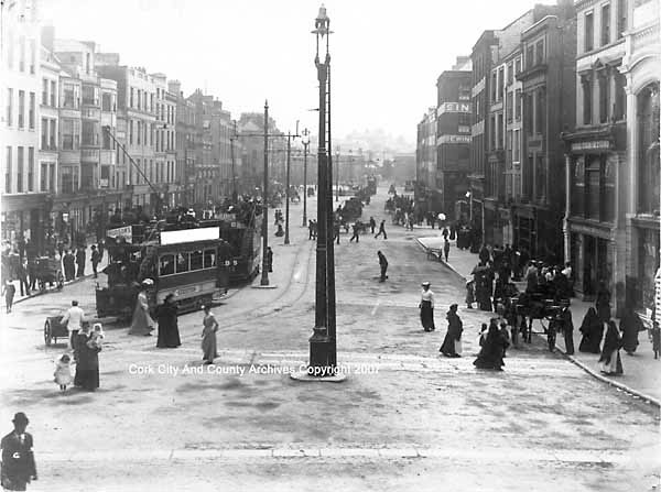
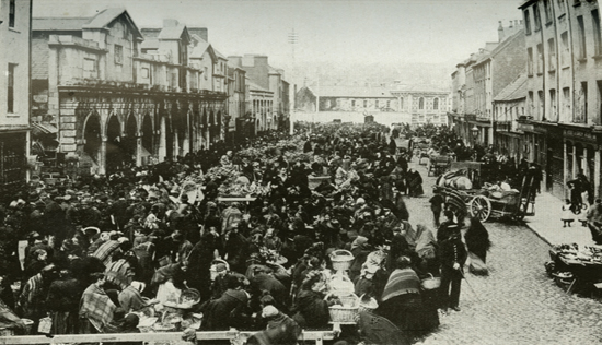
Image 1.4 A bustling Coal Quay, 1904. See the difference of this bustling crowd compared to the desert St. Peter’s Market (no wonder it didn’t survive!) Sourced from The South of Ireland Illustrated with Descriptive Letterpress and Maps.
Image 1.  Roadside Butter Market Vendors, Cork. c. 1900
Image 1.5 Roadside Butter Market Vendors, Cork. c. 1900. Photographer unknown. Sourced from Cork City Libraries.

“The virtual porosity between the ‘covered street’ that was St Peter’s and the bustling real street outside down by Coal Quay (shown above) proved ultimately fatal to its prospects. It was never able to establish its own distinct, insulated identity as the English Market had done. While the latter continued to turn a healthy profit for the corporation, justifying continued expenditure on it and copperfastening its identity in the process, the Irish Market rapidly became a loss-maker. By early 1905  fifty-eight stalls in St Peter’s were vacant and its annual income of less than £500 was over £200 less than it had been the mid-1880s. Estimated expenditure on the market for 1906 was £600.” (http://www.englishmarket.ie, accessed on 01/11/2014)

In the mid 20th Century the remaining handful of stallholders in St Peter’s Market were given notice of eviction so to speak and were offered alternative pitches in The English Market. The Irish Market was no more. Present day Cork still enjoy weekly markets down by the Coal Quay and are invited to enjoy the creaminess of it’s once world famous butter at the Cork Butter Museum. The English Market is what cork is known for, it has been a symbol of the city since its opening welcoming both citizens and tourists alike to enjoy its very successful innovations and creations of artisan foods.


I guess that explains my question; I’m sorry I ever doubted the Queen’s decision to come visit!

Image 1.6 Queen with Pat
Image 1.6 Queen with Pat O’Connell of K O’Connell Fish. Sourced from The English Market’s archives.

I hope you’ve enjoyed your perusal of my blog installment this week, despite it not being as exotic as the others’! Keep your eyes peeled for next week when I get the opportunity to showcase some of my own photography skills.

Bye, bye, bye, bye, bye, bye, bye, bye…should I just stop trying to be so Cork while I’m ahead?

Jennifer | 112302041

Planning to read more offline? Download the ePub! Simples!


Bibliography

General History of The English Market. [ONLINE] Available at: http://www.englishmarket.ie/historygallery/thehistoryoftheenglishmarket/theemergenceanddevelopmentofmarketsincorkcity/. [Accessed on 01 November 2014]
Image 1.1 Cork City and County Archives’ online exhibition, Cork: Merchant Heritage.  [ONLINE] Available at: http://www.corkarchives.ie/merchantcity/home/retailheritage/. [Accessed on 01 November 2014]
Image 1.2 and Image 1.6 The English Market’s Online Archives [ONLINE] Available at: http://www.englishmarket.ie/historygallery/gallery/. [Accessed on 01 November 2014]
Image 1.3 Michael O’Leary’s Collection [ONLINE] Available at: http://www.corkpastandpresent.ie/mapsimages/corkphotographs/michaelolearycollection/. [Accessed on 01 November 2014]
Image 1.4 The South of Ireland Illustrated with Descriptive Letterpress and Maps.

Boston and ‘the spectacle’ – Katie O’Sullivan

Hey there!

Throughout the course of this week’s blog post I hope to present an informative interpretation of urban life in early 20th Century Boston, Massachusetts.  Photography is intrinsic to our understanding of historical geography. Surveying the city in the early days of photography produced images used for educational or decorative purposes (Dennis 55). To the keen geographer in modernity however, they provide us with a record which we can analyse and interpret.

I will specifically be focusing on the idea of the spectacle and how spaces were provided for this using Franklin Park Zoo and Fenway Park as examples. Crowd engagement with celebrity has also proved to be a powerful political, cultural, economic and social tool and I will use Amelia Earhart and Babe Ruth to show this.

Compiled Map Points

Map 1.1: A quick illustration I mapped out using Google Earth to show where Images 1.2, 1.3 and 1.4 were taken. I have also roughly outlined Greater Boston.

You can click here for further online materials.

New York’s World Fair in 1935 opened with the slogan ”Dawn of a New Day” and encouraged visitors to embrace ”the world of tomorrow”. Exhibitions such as this were commonplace in the 19th and 20th centuries (starting in London’s Hyde Park) and these could be considered the beginnings of the spectacle on a large scale in the everyday urban environment.

Katie O’Sullivan | 112362596


Boston. (Arthur Griffin c.1935-55)

AG1

Image 1.1: Housed in Griffin Museum of Photography. Series: Boston Winter A. Filed under: Gelatin Silver Prints (8 x 10 in.) This aerial shot gives a good impression of Boston at this time. Faneuil Hall is centered (the  building extends past the dome), giving due importance to the longtime meeting hall and marketplace ( est. 1742)

Brown bear takes a bath at Franklin Park Zoo. (Leslie Jones c. 1917-34)

LJ4

Image 1.2: Housed in the Boston Public Library. Series: Animals: Franklin Park Zoo. Filed under: Glass negatives (4 x 5 in.) This is a terrific image showing how  animals forego their wild instinctive nature in favour of a passive human one when in captivity. It is also an interesting take on the idea of surveillance and who is really watching who, as the bear gazes directly out at us.


A zoo is at once, both a form of containment and display, inviting spectators to wander a 72-acre site, no matter the season. By putting wild animals in enclosures humankind has essentially reshaped nature (see Image 1.2). Even today, the zoo as a form of entertainment has not lost its popularity. It is easy to imagine how intimidating and exciting it was for children and adults to be so near to exotic animals they may never have otherwise encountered in 1912 when the Zoo opened. Zoos were also educational, teaching the general public about the geographical origins of the animals and their habitats, creating a more knowledgeable society.


  Amelia Earhart at East Boston Airport in Ford Trimotor (Leslie Jones c. July 1920**)

LJ3

Image 1.3: Housed in the Boston Public Library. Series: Aviation: Boardman, Earhart & Grayson. Filed under: Glass negatives (4 x 5 in.) Before the aeroplane became a common mode of transport across the globe, one can only imagine the ‘wow’ factor at seeing someone fly; fast and high. It should be noted that  there is a relatively heavy security presence around the crowd and a group of Native Americans at the top left; showing how Amelia was held in high esteem by a diverse range of people; men and women alike.


I came across countless photos of new technology and transport methods in the archives. However, I chose this particular one (see Image 1.3)  as it demonstrates the celebrity combined with air transport. It is ironic that Jervis states ‘such machines [aeroplanes were] characteristically coded as masculine’ (1998, p. 213). Following on from this, we discussed how the role of women has changed over the centuries in lectures this week. This makes Amelia Earhart all the more special as she too became an icon, a female aviator enshrouded in success and mystery, disappearing 10 years after this visit to the grounds that later became Logan Airport.


 Babe Ruth autographing at Fenway. (Leslie Jones c. 1934) 

LJ2

Image 1.4: Housed in the Boston Public Library. Series: Baseball. Filed under: Glass negatives (4 x 5 in.) As a fan of rugby myself, I can relate to the youths in this image who yearn for a souvenir that can last a lifetime. This relationship is intrinsic as an autograph on a ball or jersey can be handed down in family history with the accompanying story  ”I remember when I met Babe Ruth after that spectacular game …” as well as being of sentimental or even economic value.


Without the infrastructure of a park or stadium in which to practice and play competitively, baseball may never have taken off as a national sport. Fenway Park is iconic and the oldest Major League Baseball (MLB) park still in use (see Image 1.4). 1903 brought with it the first world series in the MLB as the Boston Americans (renamed the Red Sox in 1907) beat the Pittsburgh Pirates. Their early successes generated a large fan-base. It’s interesting to note that the fans Babe Ruth is attending to in the image are male. This shows the gender division in sports at the time.


State House fireworks. (Leslie Jones c. 4th July  1932)

LJ 1

Image 1.5: Housed in the Boston Public Library. Series: Boston: Public Buildings. Filed under: Glass negatives (4 x 5 in.) This image is the very pinnacle of  how most people would regard ‘the spectacle’; a fireworks show. However, there are politics of prestige and power involved in the organisation of such displays. This one for instance is held near the State House.

  Jervis defines the spectacle as ‘an extravagant visual entertainment… [which] dramatizes and projects the passivity of experience, its dependence on canons of representation through which its meaning is shaped and defined’ (1998, p. 344).

To conclude, the growth of celebrity and success in sport kept the public in good spirits. Meanwhile an increase in outdoor family activities, celebrating Independence Day and trips to the Zoo helped reduce potential dissention. These public events, whereby people were regulated through spectating, became a kind of safety valve, a common conclusion among political historians. The diverse range of spectacles pictured above, acted as an underhanded method of regulating Bostonians and will last infinitely through the medium of photography.

That’s all for this week,

Katie O.


** The archival record date for Image 1.3 is incorrect as this was before Amelia became well known and admired, it is more likely to have been c. 1927-28


 Bibliography.

See History | Sports and Leisure at <http://www.cityofboston.gov/visitors/about/trivia.asp&gt;

Dennis, R 2008, Cities in modernity, Cambridge University Press, UK.

Jervis, J 1998, Exploring the Modern, Blackwell Publishing, UK.

Montréal, Canada – Pierre-Joseph Cancellieri

Bonjour et bienvenue

For this week’s blog, I decided to examine an urban infrastructure project which was created in the city of Montréal during the 20th century.  In order to give you all a better idea of the city which existed in the 20th century, here is a few facts; Montréal is located on the biggest island of the Hochelaga archipelago on the Saint Lawrence river, in Québec, Canada. Downtown Montréal is on the South bank of the island, and trapped between the river and a mountain called Mount Royal.

Throughout this blog post, we will explore the construction of the tunnel,  first how it was mined through the mountain and then examine the by product effects it had on the people of Montréal, with special recognition to the creation of a new city to the north of the tunnel.

I was lucky enough to spend a year living in Montréal in 2012, so I found this week’s task incredibly interesting, it allowed me to step back in time into back to a city, which I once experienced on a daily basis! I hope you enjoy reading this post,  as much as I had creating it!

Stay tuned to learn some really interesting facts, especially relating to the power a successful urban infrastructure can create !

Pierre-Joseph Cancellieri | 114 112 124


Map 1.1 : This map illustrates the proposed plan of the tunnel, downtown Montréal and Mount Royal town.

First, we will examine a description of the project,  its effects on the city, its inhabitants and its geography. Finally, we’ll explore the difficult reality which revolved around the construction of the tunnel.

The tunnel is built under Mount Royal, a mountain which dominates the island of Montréal. Because of a fierce competition of railways companies during the early 20th century, the Canadian Northern Railways (CNR) decided to built a tunnel to compete with other railways owned by competing companies.

View of the work under Mount Royal. Fuel engines weren't used a lot because of the smoke and the lack of ventilation in the tunnel

Image 1.1: This image illustrates the work which was occurring under Mount Royal. At the time fuel engines were not frequently used due to amount of smoke produced and the lack of ventilation in the tunnel.

Due to a technical challenge, workers mostly used pickaxe and horses to dig out the rocks

Image 1.2 : Due to a lack in technological advances, workers mostly used pickaxes and horses in order to to mine the mountain; to create the tunnel.

It was a huge project, it created both a technical and financial challenge for CNR, so in order to make it profitable, they decided to create a new city based on E. Howard’s theory (Garden City). This new city would benefit from the creation of the tunnel acting as a commuter tunnel and rail system. Indeed, we can sum up the garden city model has an suburban city connected by railways line to the inner city. The train station and the commercial area are located in the centre of the garden city. Houses are around the center and they are surrounded by green fields which provide food for the city.

 ( In the bibliography, you will find two links which will provide more information on the Garden city model.) 

Town of Mount Royal in 1927, we can see the railways line, the station in the middle and an efficient streetscape to connect all part of the new city to the station

Image 1.3: This aerial photographs gives the clear picture of the town of Mount Royal (TMR) in 1927, we can clearly identify the railways lines, the station in the middle of the image and an efficient streetscape which connected the city to the station.

On the topic of the actual geography of the city, the tunnel created the same effect as if they had completely removed the mountain.  It successfully facilitated reliable transport to the north of downtown Montréal; the availability of free flowing public transport in Montreal had been transformed. With the construction of the tunnel, residential suburbs and commuters were born.

However, during its creation the tunnel faced huge difficulties. First, the Great War which destroyed mainland Europe, slowed the progress of the tunnel’s creation due to lack in the availability of resources. In 1918, when the first train set off, no ceremony celebrating its maiden journey was held due to the widespread effect of the public disease; The Spanish Flu. Unfortunately, not long after this the the company faced a financial low; mass debt threatened the company’s status and with this the tunnel’s  use. As a last resort, the company was nationalized in 1923. Following on from that, the rising rates of car sales further reduced the potential of the tunnel.

Even if the tunnel was a financial disaster for CNR, the town of Mount Royal grew and became a model city in all aspects, in its design but also in its character.

a model city in all aspects, clean roads, well dressed people, nice cars and beautiful house. In the 30's and 40's, the city was dwelled by English speaking upper class of Montréal's urban area

Image 1.4: Montreal became a model city. It was a city which was transformed; decked out with an efficient road system and examples of wealth such as expensive cars and lavish suburban homes. Interestingly, in the 1930’s and 1940’s, the city’s urban areas were home to the English speaking upper class of Montréal society. 

Nowadays, it still exists as a wonderful tool to the city of Montréal.  While built in the early 20th century, the tunnel is still  providing efficient transportation between the North and downtown Montréal.

Skyview of town Mount Royal, nowadays. Certain ideas of E. Howard have been respected such as green spaces, we can see the difference between TMR and its environment

Image 1.5: This aerial image shows the town of Mount Royal nowadays. You can clearly identify how certain ideas proposed by E. Howard have been respected due to the abundance of green spaces, this image allows us to identify the difference between TMR and its surrounding environment.

To conclude, despite the fact that car usage still remains a predominant method of private transportation in terms of commute, the town of Mount Royal retains its strong link with the tunnel.  The tunnel is the epitome of the town’s heritage, it led to its creation and subsequent success as a suburban town. In 2012 the people of Montreal honored the hundredth anniversary of the beginning of the tunnel’s drilling and creation of the town of Mount Royal; a city built beyond the original boundaries.

I hope you have enjoyed discovering the important role of urban infrastructure in the city of Montreal.

Until next week!

Pierre

Bilbliography

link 1

link 2

Sources: click here

Saint Petersburg, Russia – Aoife Cotter

” Dobro pažálovat’ “

Hello and welcome to the week’s last blog post; I hope you all have thoroughly enjoyed perusing through this week’s batch of posts!

Last week I examined the regeneration of London after The Great Fire of 1666, this week I have decided to explore the main thoroughfare of the city of Saint Petersburg, Russia; circa the early 20th century. I hope the post will give you a better understanding of main street urban infrastructure as an important public space during this period.

Aoife Cotter | 112495138


Today, Saint Petersburg is filled with rich history and culture, an unusual feat for such a young city of just three hundred years old. The city itself is built upon the banks of the Neva River. Founded in 1703 by Tsar Peter the Great (1682-1721) as his capital; the city remained the capital of the Russian Empire until the Russian Revolution of 1917.

In the late 19th century, Saint Petersburg was thriving. As capital, it was home to state officials, the military garrison and the imperial court. Its unique and dramatic architecture was the equal of any other European city of the time. Buildings such as the Winter Palace now known as the State Hermitage Museum, were representative of a lavish and thriving capital. Saint Petersburg was fast becoming a capitalist city. The effects of industrialization were evident as foreign and national factories grew rapidly within the city’s environs and banks and various other companies made Saint Petersburg their home.

Map 1.1 – A map of Saint Petersburg in 1720.  The map depicts the development of the city was only created fifteen years earlier. The map was created by Johann Baptiste Hommann

Map 1.1 – Johann Baptiste Hommann’s map of Saint Petersburg circa 1720.
This map depicts the development of the city which was created fifteen years earlier.

The Nevsky Prospect was created at Peter the Great’s behest as the boulevard which would be the main artery to the ancient city of Novgorod but quite quickly became the main street of the city, a city named in honor of Saint Peter. The street itself was named after a 13th century war hero, Alexander Nevsky. Saint Petersburg’s main shops and businesses are located on and around this grand thoroughfare. The Nevsky Prospect, from humble beginnings, has now become Peter’s lasting legacy to the city’s physical infrastructure and its people.

Image 1.2 – The Nevsky Prospect 1912. This digital photography clearly illustrates the . The availability of photographic equipment due to techonological advances in the early 19th century allowed for this image to be produced. This image illustrates a clear picture of Saint Peterburg’s citizens using the Nevsky Prospect in their daily lives.

Image 1.1 – The Nevsky Prospect, 1912. This digitalized photograph clearly illustrates the bustling main street and demonstrates Saint Petersburg’s citizens’ use of the Nevsky Prospect in their daily lives.

The Nevsky Prospect continued to evolve throughout the years. In the early years of the 20th Century, the addition of a public light infrastructure and improvements to accessibility, such as new bridges over Neva River, made the Nevsky Prospect a more inviting and accessible public space. In addition to the Winter Palace, the Prospect is home to some outstanding architectural and imposing buildings such as the Kazan Cathedral, the Gostiny Dvor building and The Church of Our Saviour on Spilled Blood which was completed in 1907.

Nevsky Prospect View

Image 1.2 – A vintage postcard from 1906 illustrates a view of the Winter Palace from the corner of the Nevsky Prospect. This image represents just one of many architectural and historical sites which are situated on the Prospect.

These landmarks enhance the overall experience of the Prospect, they complement the existing buildings of the street  which are uniform in nature.

“In the words of the poet Piotr Viazemsky, “slender, regular, aligned, symmetrical, single-colored…””

The Nevsky Prospect

Image 1. 3 – The Nevsky Prospect; circa 1910. This image clearly illustrates the Prospects success and popularity as a main street in the early 20th century and demonstrates the uniformity of the streetscape architecture.

Today, the Nevsky Prospect still exists; it is the city’s central shopping street and the hub of the city’s entertainment and nightlife. It still possesses the same function, it did in the centuries before; acting as a place of promenade for citizens and tourists alike.

“‘Public space’’ is the space where individuals see and are seen by others as
they engage in public affairs” – (James Mensch, 2007)

While the Nevsky Prospect is not a public place of recreation, it is a public space of importance and innovation as a functioning main street. In the late 19th and 20th centuries, it was the city’s central hub of activity, a space that allowed business and trades to thrive. Its significance and success as a crucial urban structure is supported by historic photographic evidence, some of which is included above.

Untitled

Image 1.4 – The Nevsky Prospect circa the early 1990’s. This image is yet again another representation of the avenues success in the early 20th century.

Image 1.4 - The Nevsky Prospect; modern day. Its function in society has not changed since its creation.

Image 1.5 – The Nevsky Prospect; modern day. Its function in society has not changed since its foundation.

While, the other contributors to this blog have examined various other processes which occurred in cities throughout the 19th and 20th century.  I firmly believe in the importance of public space. The utilization of public spaces has been established for centuries and many historic public spaces continue to act as hubs of activity in today’s society. The Nevsky Prospect is a perfect example of such a functional public space; it provides both a platform and focus for the city’s daily operations and interactions and facilitates its citizens and tourists alike.

And with that concluding sentence, I bring this week’s blog posts to a close.

Be sure to stay tuned for next week’s blog!

From Russia with love,

Aoife

Bibliography

The Facts of Saint Petersburg – Available at: http://www.saint-petersburg.com/quick-facts.asp[Accessed 21st October 2014]

Saint Petersburg History – Available at: http://www.saint-petersburg.com/history/introduction.asp [Accessed 21st October 2014]

Saint Petersburg History – Available at: http://saint-petersburg-russia.org/st-petersburg-19th-century [Accessed 21st October 2014]

Nevsky History – Available at:http://nskrip1.blogspot.ie/2012/11/the-history-of-nevsky-prospect-in-st.html [Accessed 21st October 2014]

1720 Map – Available at: http://www.raremaps.com/gallery/detail/31239/Topographische_Vorstellung_der_Neuen_Russischen_HauptResidenz_und/Homann.html [Accessed 21st October 1014]

“Public Space” James Mensch 2007-03-01o Continental Philosophy Review

Available at: http://0-link.springer.com.library.ucc.ie/article/10.1007/s11007-006-9038-x [Accessed 21st October 2014]

Concluding This Week’s Blog Posts – 7th of November 2014

Well That’s a Wrap Folks!

Thank you all once again for tuning into this week’s installment of posts! We hope you all enjoyed taking some time out to explore some examples of cities of the past with us this week.

As urban geographers, we love exploring cities; both in their past and present forms, this week we explored six individual case study cities; through our looking glass of digitalized photographs. Exploring the past is an exciting prospect for most but exploring the experiences and practices of the cities of the 19th and 20th centuries was an opportunity that we could not miss out on! We hope you enjoyed reading these blog as much as we had creating them!

If you have any questions do not hesitate to drop us an email and we will get back to you as soon as we possibly can!

Again, if you like what you see, click on this link to our twitter page where we promise to let you all know what is happening with us and the blog through our regular updates, and we even provide the possibility of learning something new from our #DidYouKnow tweets!

Lastly, we have added a new section to our blog where you can download our posts in an ePub format; please check these out for reading on the go.

Until we click again,

Aoife, Katie O, Jennifer, Donna, Katie M & Pierre

We love hearing back from our readers; be it through comments or your emails. Receiving feedback really does make our day so we’ve decided to include a weekly poll too!  Any feedback you have don’t be afraid to let us know!

THE CITY OF LIGHT AND ITS BOULEVARDS – Jennifer Egan

Bonjour et Bienvenue!

“You can’t escape the past in Paris, and yet what’s so wonderful about it is that the past and present intermingle so intangibly that it doesn’t seem to burden.” -Allen Ginsberg

For this week’s blog entry, I’ve decided to be self-indulgent and use it as an excuse to learn more about, and to then share with you, my favourite city, Paris. To date, I’ve been lucky enough to see some awe-inducing parts of the world, but none are quite like the French capital of Paris that has been hollowed and re-fashioned by history. As one walks through her boulevards, you’re captivated by something new at every corner, but it’s the seamless juxtaposition between the old and new that is most brilliant.


This week I shall be focusing on the modernizing of Paris during the Age of Enlightenment. I intend on doing this by comparing, with the aid of digital maps, pre and post Baron Haussmann’s endeavor to undertake one of the largest urban regeneration projects since the burning of London in 1666 which you can read more on in Aoife’s first installment.

Haussmann’s radical project included such things as an expanded sewer system, gas lighting for the streets, a uniform facade for the city’s building, construction of new parks and the division of Paris into arrondissements. However, for the purpose of this blog, I shall focus in on the construction and reorganization of boulevards across the city. “Think about Paris and sooner, rather than later, the word boulevard will come to mind. Boulevards – the word itself, perhaps as much as their physical reality – define this city. The word conjures up images of broad tree-lined sidewalks, elegant building, attractive stores, corner cafes, crowds of people, and the warm light of street lamps.” (Jacobs, McDonald & Rofé, 2003)

Image of The Avenue des Champs-Élysées which is a boulevard in the 8th arrondissement of Paris, 1.9 kilometres long and 70 metres wide, which runs between the Place de la Concorde and the Place Charles de Gaulle, where the Arc de Triomphe is located. The grandeur and width of this boulevards and nicely complimented by the manicured trees and large open spaces at the end of each boulevard.


Fig. 1: A Plan of the City of Paris, 1800. Source here.

As seen in the map above, the streets used to be narrow, chaotic and disorderly, leading to everywhere and nowhere. The tight confines of medieval Paris were hindering the city’s potential for growth and its desire to transform into a well-organized, modern urban hotspot. Modernity’s urban signature was seen as one of order, power and transformation. For Napolean III, that is exactly what he wanted to gain over the Parisiennes: control; boulevards were a physical representation of just that. Although many people at the time argued that the sole motivation for the construction of these boulevards was a strategic move by Napolean III and his military, Paris urban historian Patrice de Moncan wrote: “To see the works created by Haussmann and Napoleon III only from the perspective of their strategic value is very reductive. His desire to make Paris, the economic capital of France, a more open, more healthy city, not only for the upper classes but also for the workers, cannot be denied, and should be recognised as the primary motivation”. They were the places to see and be seen; lined with opulent boutiques, café bistros and hand-manicured trees. They were places where affluence could be flaunted and admired, and where, thanks to the new water and sewer systems, citizens could show off their new found cleanliness.

Blog One - Old Boulevards            Blog One New Boulevards
Fig. 2: Snippet of Map of Paris, 1800. Source here.         Fig. 3: Snippet of Map of Paris, 1889. Source here.

Even though it’s quite hard to believe, Fig. 2 and Fig. 3 are of the same location in Paris, just west of the Ile de la Cité. This contrast between the 1800 and 1889 maps illustrates the extent of Haussmann’s transformation of the city’s street-scape over a mere time-span of twenty years with examples such as Boulevard du Temple and Boulevard de Ménilmontant shown in Fig. 3.

 File:Paris-cite-haussmann.jpg
Fig. 4: “Before Haussmann” Map of Ile de la Cité,   Fig. 5: “After Haussmann” Map of Ile de la Cité,
Paris. Source here.                                                  Paris. Source here.

Another visually striking contrast of pre and post regeneration evident on the Ile de la Cité with the development of wide, traverse roadways across the island joining the two bank of the Seine.

The revamping of Paris’ streets into boulevard was, I believe, an integral part of bringing the City of Light out of the Dark Ages and into the Modern era.


Thanks for tuning in this week and sticking with me! Hope you’ve enjoyed my very first blog post, as well as the others!

Jennifer E. | 112302041

Planning on doing some offline perusing? Download the ePub!

References

Fig. 1, Fig. 2, Fig. 3 – Old Maps of Paris. [ONLINE] Available at: http://www.oldmapsofparis.com/. [Accessed 15 October 14].
Fig. 4, Fig. 5 – Ile de la Cité transformation. [ONLINE] Available at: http://commons.wikimedia.org/wiki/File:Paris-cite-haussmann.jpg. [Accessed 15 October 14].
Jacobs A. B, McDonald E. and Rofé Y, 2003. The Boulevard Book: History, Evolution, Design of Multiway Boulevards. MIT Press.
de Moncan P., 2002. Le Paris d’Haussmann, p. 34.
General information on Haussmann’s plans. Available at: http://www.arthistoryarchive.com/arthistory/architecture/Haussmanns-Architectural-Paris.html [Accessed 12 October 14].

Edinburgh – Katie McKay

Ceud mìle fàilte!

The task for this week’s blog is to use digital maps to illustrate the growing influence of modernity in a city of your choice. In order to complete this task, I will look at two maps of Edinburgh, one of which is from the eighteenth century and the other which is from the nineteenth century.

Katie McKay | 112417258


Edinburgh is the capital of Scotland and today it is described as being “one of the most distinctive and widely recognised cities in the world” (Undiscovered Scotland, 2014). However, the distinctive and widely recognisable city of Edinburgh that can be seen today differs from that of eighteenth century Edinburgh.

Map 1.1: Plan of the City of Edinburgh in 1764

John_Rocque_Plan_von_Edinburgh_1764

Creator: John Rocque. Source: http://www.commons.wikimedia.org The above map illustrates Edinburgh’s streetscape before James Craig’s grid pattern plan for the north of the city was implemented.

In the early eighteenth century, Edinburgh was an overcrowded city and in order to accommodate the population, the city was crammed with tenement buildings, thus resulting in very narrow streets in Edinburgh city (see map 1.1) (Nenadic, 2011). The modernisation of the city did not begin until the collapse of a tenement building in 1751. As a result of the tenement collapse and the dissatisfaction with the conditions in the Old Town, there was an extension to the north of the city in the 1760s which was planned to James Craig’s grid pattern system (see map 1.2) (Undiscovered Scotland, 2014).

Map 1.2: Plan of the City of Edinburgh in 1820

Blog 1 image

Creator: John Woods. Source: http://www.maps.nls.uk The above map illustrates the growing influence of modernity in the city.

 In contrast to the 1764 map of Edinburgh (see map 1.1), the growing influence of modernity in the city can be seen in the map from 1820, the influence of modernity is visible through the public squares and boulevards in the map (see map 1.2). The use of a grid pattern of public squares and boulevards illustrates how the relationship between the buildings and their surroundings were predetermined; the use of grid patterns in the planning of a city highlights the growing influence of modernity in the city.

I’ll finish this week’s blog entry with a quote from the Edinburgh World Heritage website;

“The plan seems elegantly simple but it took Edinburgh from being the medieval ‘Auld Reekie’ of the past to the grandeur and classical style of the city as ‘Athens of the North’.”

That is all for this week,

Katie M

Bibliography:

Edinburgh World Heritage. (n.d.) The New Town Plan. Available at: http://www.ewht.org.uk/learning/Athens/the-new-town-plan [Accessed 16 October, 2014]

Nenadic, S. (2011) The Rise of Edinburgh. Available at: http://www.bbc.co.uk/history/british/civil_war_revolution/scotland_edinburgh_01.shtml [Accessed 16 October, 2014]

Rocque, J. (2008) A Plan of the City and Castle of Edinburg. Available at: http://commons.wikimedia.org/wiki/File:John_Rocque_Plan_von_Edinburgh_1764.jpg [Accessed 16 October, 2014]

Undiscovered Scotland. (2014) Edinburgh. Available at: http://www.undiscoveredscotland.co.uk/edinburgh/edinburgh/ [Accessed 15 October, 2014]

Wood, J. (1823) Plan of the City of Edinburgh, including all the latest and intended improvements. Available at:

http://maps.nls.uk/view/74400026 [Accessed 15 October, 2014]

Stockholm – Pierre-Joseph Cancellieri

Hej Och Wälkommen !

SIWI_slider_1

Image 1.1: Panomaric view of Gamla Stan (old town of Stockholm)

Stockholm is the capital of Sweden and the largest city in Scandinavia. It was founded around 1250 on an island between 2 lakes; Malar Lake and Saltjsö Lake to protect other cities in the inner lands from piracy attacks. The presence of water is very important and the geography of the city is composed of islands, lakes and hills.

Map of Stockholm in 1836. Gamla stan is the central island, North of it there is Nörrmalm and South of it, Södermalm

Map 1.1: Map of Stockholm in 1836. Gamla stan is the central island, North of it there is Nörrmalm and South of it, Södermalm

Stockholm today can be compared to other cities built on water such as Amsterdam, Holland or Bruges, Belgium. Dissimilarly, its shape is closer to Paris. Gamla stan (central island of Stockholm, see Map 1.2) can be compared to l’île de la cité in Paris and Nörrmalm and Södermalm to the both sides of the Seine river (see Map 1.1).

Stockholm is interesting due to its old tradition of planning, as it was the first European city to institute planning laws in 1640. Stockholm’s streetscape rapidly took on a grid form, only Gamla Stan has kept its medieval character.

Now we will compare two districts of Stockholm, the first being; Gamla Stan an old town filled with medieval characteristics and then Nörrmalm which is the center of Stockholm which has been planned for almost 4 centuries.

First, Gamla Stan is the old town and the medieval center of Stockholm. It becomes really obvious when we look to the streetscape. This area, like London (see Aoife’s blog), was rebuilt after fires and yet this district has kept its narrow streets (see Image 1.2).

Map 1.2: Map of Gamla Stan 1547, a typical medieval district

streetscape of Nörrmalm. The graduation of red to yellow shows the different grid shape and the green represents open spaces and park

Map 1.3: streetscape of Nörrmalm.

Nörrmalm, however is different. This district was created later when the city had to extend. Since the first settlements in Nörrmalm, planning had been a light to develop the city, compared to others cities in Europe which faced uncontrolled developments. Moreover, the plan of 1866 (see Map 1.3) shows us how this part of the city became the center (railway station) and also how the grid shape (see Image 1.3) had taking in account of the geography of the place (by the graduation of red). This place prepared Stockholm for the future and welcomed new inhabitants. It also provided hygienic ideas and green spaces to improve the quality of life within the city.

A street in Gamla Stan

Image 1.2: A street in Gamla Stan

skyview of the grid of Nörrmalm

Image 1.3: skyview of the grid of Nörrmalm

Pierre-Joseph Cancellieri| 114112124

Source (click here)

Rome – Donna Clifford

Ciao e benvenuto a Roma


The city of the early Roman kings was said to be made up of three divisions, or “tribes” (tribus, a third part, from tres, three); people of Latin, Sabine and Etruscan origin settled on the hills, . They all soon came to be incorporated as a part of the whole city community. The three settlements were gradually united into a single city-state with common social, political, and religious institutions, Rome was born. By this union the new city became strong and able to compete successfully with its neighbours.The first walls were built around the Palatine by Romulus, first king of Rome.

______________________________________________________________________________________________________

The form of urban public spaces in towns is an issue that has always been topical in democratic societies. An urban public space is a complex system where all components have their own specific roles. Not only its definition and spatial organization but also visual gardens or parks  are important.

Streets

A street appears in a city plan like a line, connecting one place to another. A street is made up of residential homes as well as having a business function.

Streets in Rome, just like the rest of Europe, got inspiration from boulevards of Paris at the end of the 19th century: the large span of streets and the integration of alleys. An example of a boulevard of Rome, newly renovated in an creative way, is Viale della Pyramide Cestia.

1792 Plan_des_alten_Roms Schrambl

Map 1.2 – Aerial map of Rome 1792

Squares

A square is the heart of the city: Squares in Rome are known as Piazza It is where social, political and cultural events take place. Like streets, squares also perform the business function or can be used just for staying there getting lost in time; however, they provide more space for various happenings, both from social and compositional points of view. The square has a distinct atmosphere, from intimate to monumental, for example St. Peters Square; Right in the heart of the Vatican city.  It is known as the greatest square and is the majestic access to St Peter’s Basilica, the centre of Christianity. http://www.rome.info/squares/

SAMSUNG DIGITAL CAMERA

Image 1.1 – St. Peters Square, Rome.

That’s all for this week,

Donna

Bibliography


Williams, R., 2008. From Romulus to Romulus Augustulus: Roman History for the New Millennium. Illinois USA: Bolchazy – Carducci

http://www.rome.info/squares/


http://www.the-colosseum.net/history/maps.htm


Amsterdam: Dam Square and “the public” – Katie O’Sullivan

As the Dutch would say; Hallo en welkom!

 My task today is to introduce and discuss some digital maps of my chosen city, that being Amsterdam.
I will compare the city’s historic origins, racing through the centuries, to the modern day; with a focus on Dam Square and the idea of ‘the public’. As a visual aid, I have also included some of my own photos and you can click here for further online materials.

I have been lucky enough to see some beautiful countries on my travels, each containing cities oozing with their own unique charisma; whether inherited or accumulated. One which felt the most foreign to me personally, was the city of Amsterdam. You could not come across a better example of man shaping nature from the very first settlements.

Katie O’Sullivan | 112362596


Key moments: Statistics and figures:
  • Chartered town in 1300
  • End of 15th C. city expansion
  • 17th C (Golden Age)
  • 20th C social upheaval and population change
    • Early 1900s – 1934, unrest and revolts, resulted in new pavement design in the city (removing bricks)
    • May 1945, 22 people shot dead and many injured in Dam Square by German supporters
  •  More than 800,000 inhabitants and 178 nationalities
  • More than 8,000 buildings survive from the 16th-18th C.
  • 165 canals (historically important for trade and navigation)
  • 40 parks
  • 216 trams
  • 75 museums
Source and here.
      The Amsterdam of today is similar to what locals and visitors would have witnessed in the golden age or thereafter. As can be seen in my 18th C maps below (see Map 1.1 and 1.2), Dam square has existed for centuries. Though the dam originally functioned as flood protection for the city, the square now marks a hub of cultural activity. Centrally located and boasting a relatively small 200 x 100 metre gathering place, it draws the ordinary person towards the Royal Palace (see Image 1) and might have acted in a similar fashion to the boulevards of Paris (check out Jennifer’s blog), as an exhibition space for its citizens to flaunt their affluence, or publicly lament their disadvantaged situation.
Map 1.1: Reiner Ottens Map, c. 1727. Source.            Map 1.2: Gerrit Droogenham Map, c. 1725-1750. Source.
Ottens Map

Scale 1:7 650. Publishers: Reiner and Josua Ottens. The orientation of this map is not accurate. The city appears to have been broken into sections. The base of the map contains numbered lists, which detail street names. The presence of many ships indicates the city’s rich naval and trading past.

Droogenham Map

Scale: 1:25 000. Publisher: Joshua Ottens. This map is more accurate in terms of orientation, but provides much the same idea of the city expansion. for more on the city over time please see this video.


Next to the palace is the Nieuwe Kerk. Royal family members are associated with this church and so two symbols of Dutch authority dominate the surrounding landscape. A third symbol of power also exists, that of the National Monument, directly opposite the Palace (see Image 2 and Map 1.3 or 1.4 for contrast, without the monument in place).

Image 1: Dam Square and the Royal Palace, 2013          Image 2: The National Monument, 2013

P1020598

View of Dam Square and the Koninklijk Paleis (originally the Stadhuis). You can see the grand imposing facade towering over the people in the square, which has a simple layout. Also visible are a number of bicycles, a common method of transportation in a city boasting flat roads.

P1020596

Located off Dam Square. Erected for the Dutch who lost their lives in WWII (1956). Urns within the monument contain earth from each Dutch province as well as former colonies.


Regulation regarding the city and sex is often intended to reduce public disorder. By confining the workers to certain areas such as the red light district, only streets away from the Square, ‘the public’ are less likely to encounter ‘‘local indecency’’ and uncivilized behavior as Dennis (2008, p. 148-151) remarks, unless they seek it out (see Map 1.3)

Map 1.3:  Detail of (Map 1.1)                                                          Map 1.4: Detail of (Map 1.2)

Ottens Map Detail

‘Den Dam’ seen here for ‘Dam Square’. The Royal Palace and the Church can also be seen in this illustration. The pink outlined area to the left of the map has become synonymous with the sex industry in modern times. There is an abundance of adult-stores, hostels and the infamous red light district, which lies a few streets back.

Droogenham Map Detail

The circle, large rectangle and small rectangle midst open blank space represent the Palace, Church and Square. In this enlarged image it is easy to see the construction and design of streets and canals and how built up the area surrounding these points is, even in the 18th C.


Males predominantly visit the red light district, whereas females stick to the imagined ‘safety’ of the main square. The impact of design and regulation then is that public space has been engendered and the modern night time economy exemplifies this.

One author concluded,

”The Dam is the city’s beating heart.” (Dutch Amsterdam 2013)

On a final note I look forward to witnessing the future endeavors of Amsterdam as global cities continue to modernise.

That’s all for this week,

Katie O


Please consider and perhaps respond to the following if you would like to comment on this post.

     In one hundred years will Amsterdam still be living off its legacy; or will the city and its people have forged another avenue through which to explore and implement modernity?  


Bibliography:

Dennis, R 2008, Cities in modernity, Cambridge University Press, UK.
Dutch Amsterdam 2012, accessed 6 October 2014, <http://www.dutchamsterdam.nl/dam-square-amsterdam&gt;.
Image 1 and Image 2 are my own photos, 2013.