Urban Architecture and the Quays of Cork- Katie O’Sullivan

Dia duit don uair deireanach! 

For our non-Gaelic speaking viewers that’s ‘Hello for the last time’. This is my final blog post as part of our module assignment. I really hope you enjoyed my two previous posts on Amsterdam and Boston and came away with an improved knowledge of the public and the spectacle as well as finding out more about the cities themselves.

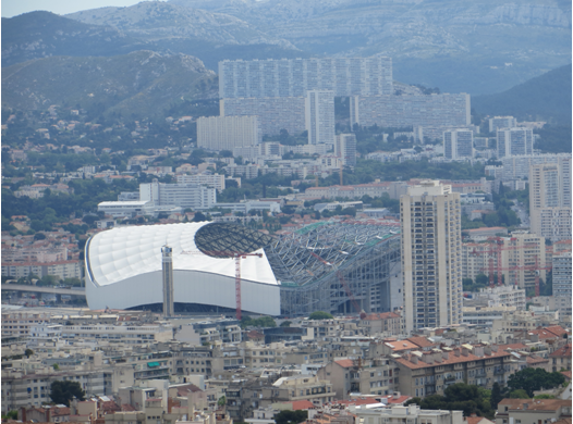
This week we were asked to discuss our chosen city in relation to either Material Culture or Urban Architecture through the use of our own offline materials. In Katie M’s entry this week she looked at the Dublin Docklands and in the name of Munster/ Leinster rivalry I would like to discuss the area around Albert Quay and Lapps Quay including City Hall, the Clarion Hotel, , the Custom House and Port of Cork. This area in fact remains a unique and popular location for gatherings, hosting events such as the Cannonball Race in August 2013 and Cork Rebel Week in October of the same year, both of which are illustrated in the further links page.

Katie O’Sullivan | 112362596


 The Port of Cork (2013)

P1040743

Image 1.1: The sign is self-explanatory. The Custom House built in the early 19th C and warehouses lie just behind the sign. Taken in August at the annual Cannonball charity run (Katie O’Sullivan 2013)

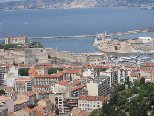
For those readers who don’t already know, Cork city is located in the South of Ireland, just upstream of the River Lee in the northwest corner of Cork harbour (check out the embedded map below). Two quick facts:

– The port of Cork is the second busiest Irish port and has several berthing points including Cork City, Tivoli, Cobh and Ringaskiddy.

– The regeneration of the Docklands is an ongoing venture.

Cork City Hall (2013)

P1050534

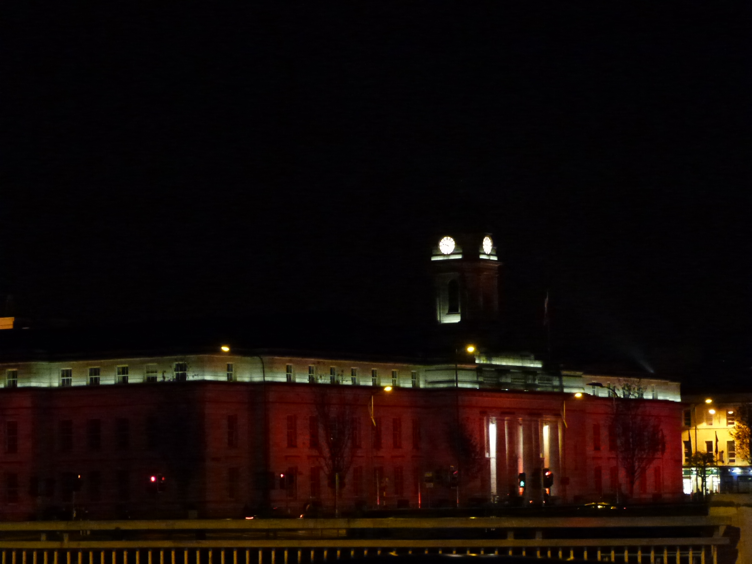
Image 1.2: City Hall bathed in red and white (the colours of Cork) for Rebel Week. This is an interesting fusion of an historic façade decorated via modern technology to show pride in the city (Katie O’Sullivan 2013)

Kraftl (2009, p. 25-28) alludes to a landscape of power where buildings mediate and display certain interests to the detriment of others. Such influences are evident in that City Hall (see Image 1.2) and even more so the Customs House (see Image 1.3) seem out of place or neglected in comparison to the sleek buildings they now stand near (comfortable spaces of commerce and entertainment). This could be taken as in impact of globalisation on form and structure, letting go of heritage styles and adopting an ‘international architecture’ style. In doing so we are losing links to the past.

Customs House at the Port of Cork (2013)

P1040738

Image 1.3: The rundown and gated Customs House seems unappealing and perhaps even dangerous. Yet if you are to approach these older areas of the city quays you can find a rich marine history associated with the port, not to mention a variety of shipping vessels to admire (Katie O’Sullivan 2013)

The buildings along Albert Quay are from the early 20th Century c. 1935; an echo of the past and no more than three storeys high. In juxtaposition Lapps Quay boasts modern, streamlined buildings at least four storeys high; advocating modernity. These buildings consist of a Hotel, Restaurant and a wide variety of offices and services showcasing the area’s financial, leisure and commercial function.

The Boardwalk (2013)

P1040817

Image 1.4: This landscape of power is especially evident on the refurbished boardwalk area linking Lapps quay to the Customs House. Examining the area with a critical eye on the urban experience, you really feel as if it might be unsafe to go past this point and why would you want to explore older buildings when you can relax here with a river view or engage in tourist or leisure activities on the river? (Katie O’Sullivan 2013)

 The Elysian Tower

P1040739

Image 1.5: Cork’s answer to the skyscraper, the Elysian Tower, clearly stands above the surrounding buildings on the other side of the River Lee. The distinction between building styles is particularly evident in this composition (Katie O’Sullivan 2013)

‘Skyscrapers represent the ultimate expression of capitalist financial power in urban space’ (Kraftl 2009, p. 28)

This can perhaps be seen with the construction in 2008 of the 17-story Elysian Tower which now dominates the city skyline looking South from the Quays.

In conclusion it is clear that this area of Cork city has undergone a huge transformation in urban architecture and the experience of the city for locals and tourists of the past, present and future has been dramatically altered.  There is a proposal to build an events centre on Albert Quay which it is hoped will kick-start major regeneration; downriver from City Hall and reaching as far as Pairc Ui Chaoimh, as envisaged in the City Council’s Development Strategy. In addition the strategy plans to reinstate lost boardwalks, widen the pavements and treat the river to bring a more appealing look to the ‘pedestrian gateways to the city‘. If Dublin’s final output is anything to go by, there are many changes still to come in the regeneration of Cork’s greater dockland area.

‘A development strategy to compete with other Irish and European  waterfronts…the strategy promotes best practice in urban design and sustainable development…over a phased period of 20-25 years.’ Cork City.

That’s a wrap! Thanks for staying with us on our journey through historical cities and their diverse geographies and I hope you enjoyed this week’s post just as much as the others.

Katie O


Bibliography:

‘An enhanced use of the river’, Cork City, accessed 20 Nov 2014, <http://www.corkcity.ie/media/An%20enhanced%20use%20of%20the%20river.pdf&gt;.

‘City Hall, Cork’, Cork Past and Present, accessed 25 Nov 2014, <http://www.corkpastandpresent.ie/mapsimages/corkphotographs/corkcameraclubhistoricalphotos/cityhallcork/&gt;.

‘Custom House’, Cork Past and Present, accessed 27 Nov 2014, <http://www.corkpastandpresent.ie/mapsimages/corkphotographs/corkcameraclubhistoricalphotos/customhouse/&gt;.

‘Custom House Yard’, Cork Past and Present, accessed 27 Nov 2014, <http://www.corkpastandpresent.ie/mapsimages/corkphotographs/corkcameraclubhistoricalphotos/customhouseyard/&gt;.

‘Docklands’, Cork City Council, accessed 26 Nov 2014, <http://www.cork.ie/explore/maritime/docklands/&gt;.

‘Key landowner backs docklands centre project’, The Irish Examiner, accessed 24 Nov 2014, <http://www.irishexaminer.com/ireland/key-landowner-backs-docklands-centre-project-258396.html&gt;.

Kraftl, P 2009, ‘Urban Architecture’ International Encyclopaedia of Human Geography, pp. 24-31.

‘Port of Cork’, Wikipedia, accessed 26 Nov 2014, <http://en.wikipedia.org/wiki/Port_of_Cork&gt;.

‘The Elysian’, Wikipedia, accessed 26 Nov 2014, <http://en.wikipedia.org/wiki/The_Elysian&gt;.

‘Vision, A sustainable approach, delivery’, Cork City, accessed 20 Nov 2014, <http://www.corkcity.ie/media/The%20Vision,%20A%20Sustainable%20approach,%20delivery.pdf&gt;.

Marseille, France – Aoife Cotter

Bonjour et Bienvenue!

Welcome to this weeks last batch of posts!

While last week I explored the importance of the main thoroughfare of Saint Petersburg, Russia; circa the late 19th and early 20th century, this week I decided to change it up once again!  The process of telling a story of a city is always a tricky one; moving away from photographs sourced online, I am delving into my own family’s albums in order to give you all a view of the city through my own camera lens. This week’s post will be centered on the city of Marseille in France. I will specifically examine how the modern city of Marseille has embraced its cultural and historical character while in keeping with the modernity of the 21st century.

 Aoife Cotter|112495138


­­­­­­­­­Marseille is proudly France’s second largest city, after Paris. Due to its prime location on the Mediterranean coast, Marseille has always been a port city . Once known as Massalia; it was home to the first permanent Greek settlement and acted as a primary trading post for the Greek Empire. Over the centuries the Marseille metropolitan landscape has been witness to various changes; the introduction of various landmarks have enriched the cityscape and more recently the process of urbanization has transformed the city once again.

In April, my parents, in celebration of a landmark anniversary, ventured on a Mediterranean cruise. They explored a range of cities dotted along the Mediterranean coast; Marseille was one of these cities. Although it was a quick visit, while in Marseille they discovered some of the cultural landmarks which illuminate the cityscape.

Marseille’s Vieux Port is one of the grand Mediterranean ports, its World Heritage-listed site status has ensured that it is one of Marseille’s main tourist attractions. Tourism is a major part of Marseille’s economy, the areas surrounding the Old Port are filled with coffee shops, muesums, restaurants and open public space. All of these are of primary importance in a tourist orientated space.

Image 1.1 -

Image 1.1 – This first image depicts the area of the Vieux Port (The Old Port), it was captured as the ship came into port. The panoramic image illustrates how the mountains effectively encircle the modern city built in its valley. It provides a good example of where the modern high rise housing styles meet just one of Marseille’s many culturally and architecturally rich builds. This fortification, which guards the Old Port, is known as the Fort Saint Jean; built in 1660 by King Louis XIV.

The city is deeply marked by its colorful past. There is a clear juxtaposition of how the old style architecture meets the new modern builds in the city. This mix creates a unique vibrancy, it enhances the appeal and overall experience of the city. For my parents, arriving into the port of Marseille was a very powerful experience. They, like many others, were drawn to the city’s blend of architecture as they began their approach into the city’s port. The effects of urbanization is clearly evident here in Marseille is exemplified by the density of high rise housing nestled into the surrounding mountain.

Image 1.1

Image 1.2 – Even amongst the new builds of the late 20th century and early 21st century, the Basilica still stands tall as a beacon of Marseille. The Basilica also known as the Notre Dame de la Garde is just one of many culturally and historically important landmarks in Marseille; located just south of the Old Port.

Image 1.4

Image 1.3 – A closer look at Notre Dame de la Garde. While it is a functioning Basilica, it also functions as a major tourist attraction for the city. An example of this is the petite train parked just to the left of the image. On the back of this in 2013,  Notre Dame de la Garde unveiled its own new museum presenting 800 years of the Basilica and its place in the history of Marseille..

The city’s stance and success in embracing its individual culture and history was recognized in 2013 as the city was honored with title of; the European Capital of Culture 2013. The global recognition has given the city yet another status boost, providing another captivating reason to explore the city.

IMAGE 1.3

Image 1.4 – The Port Vieux Pavillion ; a giant mirror canopy designed by architectural firm Foster and Partners at Marseille Vieux Port. This open public space acts as a place of recreation and reflection as it reflects both its viewers and surroundings. It is a huge attraction for Marseille’s citizens and tourists alike.

The redevelopment of Marseille’s Vieux Port was jointly awarded the 2014 European Prize for Urban Public Space at a ceremony in Barcelona on the 25th of April 2014. The Prize was established to recognize the public character of urban spaces and their capacity for promoting social cohesion.

Image 1.6

Image 1.5 – Redevelopment is still occurring in Marseille today. The array of architectural styles in the city bursts from this photograph, ranging from typically Mediterranean clay roofed houses and apartments to high density apartments and office buildings.  Pictured here is the Velodrome Stadium (Stade Velodrome) which was photographed in April 2014.

Fun Fact: Marseille played host to two major sporting events, the first being; the FIFA World Cup in 1998 and the second; The Rugby World Cup in 2007.

In 2016, France will play the role of host country for the UEFA European Football Championships. Marseille’s Stade Velodrome will play host to some of the games. It is located in the south of the city, on the north shore of the Huveaune River. While an ultra modern building, it provides a prime function in terms of the availability of recreational based activity and supports the internal economy of the city.

Image 1.6

Image 1.6 – This image was taken from outside the Basilica; the highest viewing point of the city. It presents a portrait of the cityscape; showing both the density and variety of housing styles, public green spaces and the port and surrounding waters. In the back drop of the photograph are the two forts which once used to protect the city. The first; Fort Saint – Jean and the second; Fort Saint – Nicolas are on the right and left hand side of the image; respectively.

Marseille is a city filled with both modern and historically significant builds. The success of the city lies within its ability to allow these forms to live side by side in harmony. A modern city, in order to survive, needs change and redevelopment, but the markers of the past should be included in the process. The significant landmarks of Marseille have survived the passage of time and are being embraced today both by the city’s citizens and visiting tourists alike. The city of Marseille will no doubt benefit from hosting some of the European Championship games. They will entice thousands of people into the city, in turn creating a mini boom for the city’s businesses and service sector. They will also uplift the city’s global image as a city which ensures the survival and upkeep of its past and historically symbolic architecture.

On that concluding note, I bid a final farewell to all of you.

Th th th th th th . . . that’s all folks!

Aoife

Bibliography

All of the images included in today’s blog post have been kindly donated by my father.

Marseille History – Available at: http://en.wikipedia.org/wiki/Marseille [Accessed 1 November 2014]

UEFA European Championship 2016 Information – Available at: http://fr.uefa.com/uefaeuro-finals/hosts/france/city=2201/index.html [Accessed 4 November 2014]

Marseille’s Vieux Port awarded the 2014 European Prize for Urban Public Space – Available at: http://www.fosterandpartners.com/news/archive/2014/04/marseille-vieux-port-wins-european-prize-for-urban-public-space/ [Accessed 4 November 2014]

Port Vieux Pavillion – Available at: http://www.dezeen.com/2013/03/06/vieux-port-pavilion-by-foster-partners/ [Accessed 4 November 2014]

Concluding Our Very Last Blog – 28th of November 2014

And So We Face the Final Curtain…

We would love to pass this task onto someone else, but alas, we knew this day would come eventually; saying goodbye is always a hard one! . Collectively, we would all like to thank you for tuning in on a regular basis! Your clicked mouses and scrolled track-pads constantly checking in with us over the past two months is an act which has made us all very happy. The process of blogging was a new and unfamiliar territory for most of us but now an experience we will never forget!

We have thoroughly enjoyed creating these various posts over the last few weeks. We ourselves, along with you, have explored cities such as London, Boston, Montrèal and Paris (only some to mention). By delving into their inner workings, architecture and daily functions; we have discovered the true importance of the past and how it really does shape the future! As geographers conducting our research for these posts allowed us to explore the cities of the past and fully comprehend that such cities have laid the base foundations which the modern global cities, we all know today, are built upon.

As some of you may already know, we have added a new section to our blog where you can download all of our posts in an ePub format; as the blog has come to a close why not download them  as a token to remember us by!

For now, from all of us here at Drawing From The Archives,

One last time,

So long, farewell, Auf Wiedersehen, good night !

Aoife, Jennifer, Donna, Katie O’, Katie M. & Pierre.

Concluding This Week’s Blog Posts – 7th of November 2014

Well That’s a Wrap Folks!

Thank you all once again for tuning into this week’s installment of posts! We hope you all enjoyed taking some time out to explore some examples of cities of the past with us this week.

As urban geographers, we love exploring cities; both in their past and present forms, this week we explored six individual case study cities; through our looking glass of digitalized photographs. Exploring the past is an exciting prospect for most but exploring the experiences and practices of the cities of the 19th and 20th centuries was an opportunity that we could not miss out on! We hope you enjoyed reading these blog as much as we had creating them!

If you have any questions do not hesitate to drop us an email and we will get back to you as soon as we possibly can!

Again, if you like what you see, click on this link to our twitter page where we promise to let you all know what is happening with us and the blog through our regular updates, and we even provide the possibility of learning something new from our #DidYouKnow tweets!

Lastly, we have added a new section to our blog where you can download our posts in an ePub format; please check these out for reading on the go.

Until we click again,

Aoife, Katie O, Jennifer, Donna, Katie M & Pierre

We love hearing back from our readers; be it through comments or your emails. Receiving feedback really does make our day so we’ve decided to include a weekly poll too!  Any feedback you have don’t be afraid to let us know!